 Filter: Categories of Wisconsin Historical Images
Filter: Subject of indians of north america
Filter: County of Waupaca
Filter: Categories of Wisconsin Historical Images
Filter: Subject of indians of north america
Filter: County of Waupaca
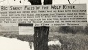
| Date: | 1920 |
|---|---|
| Description: | Sign for the toll road at Big Smoky Falls on the Wolf River. The sign reads: "Big Smoky Falls of the Wolf River. Many years ago before 1925 there was no ro... |
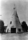
| Date: | 05 26 1937 |
|---|---|
| Description: | Exterior view of a filling station built to resemble a teepee. |

| Date: | 1941 |
|---|---|
| Description: | This pictorial map shows sites related to Indian legends, mounds, and trails in the Chain O' Lakes region in southwestern Waupaca County, Wisconsin. |
If you didn't find the material you searched for, our Library Reference Staff can help.
Call our reference desk at 608-264-6535 or email us at: