 Filter: Categories of Wisconsin Historical Images
Filter: Subject of indians of north america
Filter: County of Kenosha
Filter: Categories of Wisconsin Historical Images
Filter: Subject of indians of north america
Filter: County of Kenosha

| Date: | 1905 |
|---|---|
| Description: | This pictorial representation of part of Lake Winnebago and the Fox River in 1703, showing interactions between white beaver hunters and the Iroquois is ta... |
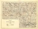
| Date: | 1929 |
|---|---|
| Description: | Map of the Menominee Indian Reservation. Legend reads: "Topographic and cultural data were obtained from field notes of a timber cruise and land classifica... |
If you didn't find the material you searched for, our Library Reference Staff can help.
Call our reference desk at 608-264-6535 or email us at: