 Filter: Categories of Wisconsin Historical Images
Filter: Subject of indians of north america
Filter: County of Bayfield
Filter: Categories of Wisconsin Historical Images
Filter: Subject of indians of north america
Filter: County of Bayfield
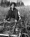
| Date: | 1960 |
|---|---|
| Description: | An Ojibwa woman, Francis Mike, harvesting wild rice in a boat on Totogatic Lake. |
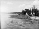
| Date: | |
|---|---|
| Description: | Three tipis on the shore of East Lake, now called Lake Tahkodah. |
| Date: | |
|---|---|
| Description: | Tipis along the shore of East Lake, now called Lake Tahkodah. |
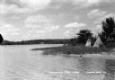
| Date: | |
|---|---|
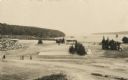
| Description: | People on the shore of East Lake (now called Lake Tahkodah) by the Gifford residence, with tipis in the distance. |

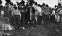
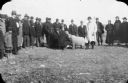
| Date: | 07 04 1913 |
|---|---|
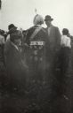
| Description: | Indian "Powwow" and Lacrosse contest between various Indian reservations. |
| Date: | 1913 |
|---|---|
| Description: | Powwow at the Red Cliff Indian Reservation on the shores of Lake Superior. |
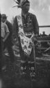
| Date: | 1913 |
|---|---|
| Description: | Native American at a Red Cliff Indian Reservation Powwow on the shores of Lake Superior. |
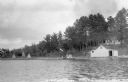
| Date: | 1936 |
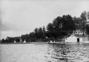
|---|---|
| Description: | View from water of people sitting in a canoe on the shore of East Lake next to a dock on which people are standing and a flag is waving. On shore there is ... |
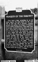
| Date: | 1937 |
|---|---|
| Description: | Historical marker describing an Ojibwe legend that took place on Siskiwit Lake. |
| Date: | |
|---|---|
| Description: | Photographic postcard of a scene from the Apostle Island Indian Pageant. A large group of young children in white shirts are sitting along a sloped hill ne... |
| Date: | |
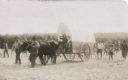
|---|---|
| Description: | Photographic postcard of a scene from the Apostle Island Indian Pageant. Two children are sitting aboard a covered wagon pulled by a pair of steers while t... |

| Date: | 1900 |
|---|---|
| Description: | This 1900 map shows the township and range system, sections, cities and villages, railroads, roads, vacant land and land sold by the Wisconsin Central Rail... |
| Date: | |
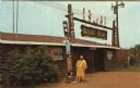
|---|---|
| Description: | View of the exterior of the "Indian Bowl," a venue for powwows. A Native American woman is standing in front next to the totems. |
| Date: | 07 04 1913 |
|---|---|
| Description: | Indian "pow-wow" and lacrosse contest between various reservations. |
| Date: | 07 04 1913 |
|---|---|
| Description: | Indian "pow-wow" and lacrosse contest between various reservations. |

| Date: | 1935 |
|---|---|
| Description: | This topographical map of the forest preserve shows highways, roads, trails, telephone lines, Native American reservations, Ranger sub-stations, state nurs... |

| Date: | 1912 |
|---|---|
| Description: | This map shows a school reserve, swamp land, railroads, and selected buildings. |

| Date: | 2000 |
|---|---|
| Description: | This map shows national parks, county and state forests, Indian reservations, municipal land, private land, docks, boat access, camping, and points of inte... |
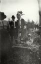
| Date: | 1925 |
|---|---|
| Description: | A man in a light-colored overcoat, possibly Joseph Wojta, standing behind a sheep being inspected by two other men. A group, including men, women and child... |
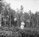
| Date: | 1920 |
|---|---|
| Description: | Mrs. Antoine Buffalo, Jr., posing in a field at the edge of a wood. She is a member of the Chippewa (Ojibwe) tribe, and a farmer. On the right are several ... |
If you didn't find the material you searched for, our Library Reference Staff can help.
Call our reference desk at 608-264-6535 or email us at: