 Filter: Categories of Wisconsin Historical Images
Filter: Subject of indians of north america
Filter: Community of Lac du Flambeau
Filter: Subject of land
Filter: Categories of Wisconsin Historical Images
Filter: Subject of indians of north america
Filter: Community of Lac du Flambeau
Filter: Subject of land

| Date: | 1974 |
|---|---|
| Description: | This 1968 map identifies resorts in the Lac du Flambeau Indian Reservation region of Wisconsin, covering parts of Iron, Vilas, Oneida, and Price counties. ... |

| Date: | 1911 |
|---|---|
| Description: | This map shows railroads, roads, swamps, a school site and farm, and a mill site. The map includes a "typical township" diagram. Lac du Flambeau, Long Lake... |

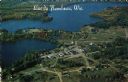
| Date: | |
|---|---|
| Description: | Kodachrome postcard of an aerial view of Lac du Flambeau village and the surrounding chain of lakes. Caption reads: "Lac du Flambeau, Wisconsin." Text on b... |
| Date: | 1984 |
|---|---|
| Description: | Aerial postcard of Lac du Flambeau village and surrounding lakes. Caption reads: "Lac du Flambeau, Wis." Text on reverse reads: "On State Hwy 47 between Po... |
If you didn't find the material you searched for, our Library Reference Staff can help.
Call our reference desk at 608-264-6535 or email us at: