 Filter: Categories of Wisconsin Historical Images
Filter: Subject of human settlements
Filter: Creator Name of Unknown
Filter: Categories of Wisconsin Historical Images
Filter: Subject of human settlements
Filter: Creator Name of Unknown
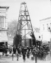
| Date: | 1885 |
|---|---|
| Description: | Elevated view of a crowd of people standing near an artesian well. Men wearing long coats and hats to protect them from the water are standing on and unde... |

| Date: | 1922 |
|---|---|
| Description: | A plat map of the township of Delton near the Wisconsin River. |

| Date: | 1875 |
|---|---|
| Description: | Elevated view of several buildings, with bridge and railroad tracks, and the Fox River. In the foreground on the right is the Commercial House, with three ... |

| Date: | 01 1944 |
|---|---|
| Description: | A group of men encircle a lightpost. A caption identifies them as "Hosiery Union housing project men's choral group." |

| Date: | 1870 |
|---|---|
| Description: | Elevated view of an unpaved main street, with the Village House across the street in the center background. Wooden buildings and wooden sidewalks are on bo... |

| Date: | |
|---|---|
| Description: | View of a house with a tree in the front yard. Caption on front reads: "Wishing you a very happy Christmas and New Year." On the reverse is written: "Would... |
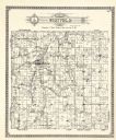
| Date: | 1922 |
|---|---|
| Description: | A plat map by Westfield created by George A. Ogle & Co. |

| Date: | 1912 |
|---|---|
| Description: | A plat map of the township of Casco. Created by Geo. A. Ogle. |

| Date: | 1857 |
|---|---|
| Description: | Green Lake County plat map, T. 16 N, R. |

| Date: | 1857 |
|---|---|
| Description: | Green Lake County plat map, T. 17 N, R. 13 E. |

| Date: | 1857 |
|---|---|
| Description: | Green Lake County plat map, T. 15 N, R. 13 E. |

| Date: | 1857 |
|---|---|
| Description: | Green Lake County plat map, T. 14 N, R. 13 E. |

| Date: | 1857 |
|---|---|
| Description: | Green Lake County plat map, T. 16 N, R. 12 E. |

| Date: | 1857 |
|---|---|
| Description: | Green Lake County plat map, T. 17 N, R. 12 E. |

| Date: | 1857 |
|---|---|
| Description: | Green Lake County plat map, T. 14 N, R. 12 E. |

| Date: | 1914 |
|---|---|
| Description: | Pg. 44 West Half of Marion Township. Pg. 45 East Half of Marion Township. |

| Date: | 1914 |
|---|---|
| Description: | A farmer's directory of Marion Township listing farmers and locations of their farms. |

| Date: | 1857 |
|---|---|
| Description: | Green Lake County Abstract plat map, T. 14 N, R. 11 E. |

| Date: | 1857 |
|---|---|
| Description: | Green Lake County abstract plat map, T. 16 N, R. 11 E. |

| Date: | 1857 |
|---|---|
| Description: | Green Lake County abstract plat map, T. 17 N, R. 11 E. |
If you didn't find the material you searched for, our Library Reference Staff can help.
Call our reference desk at 608-264-6535 or email us at: