 Filter: Categories of Wisconsin Historical Images
Filter: Subject of education
Filter: Subject of trails
Filter: Categories of Wisconsin Historical Images
Filter: Subject of education
Filter: Subject of trails
| Date: | |
|---|---|
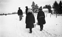
| Description: | Winter scene with children bundled-up against the cold carrying their lunch pails down a snowy rural path to the one room school house called the Pahquahah... |

| Date: | 1907 |
|---|---|
| Description: | The Yahara River Parkway, with the old Lapham School at 1436 East Dayton Street at North Thornton visible on the righthand side. |

| Date: | 1908 |
|---|---|
| Description: | View of the courthouse and school building. Caption reads: "Court House and School Bldg., Sturgeon Bay, Wis." |
| Date: | |
|---|---|
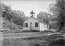
| Description: | Lower Beetown clapboard schoolhouse with bell tower and path. |
| Date: | |
|---|---|
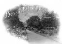
| Description: | Promotional postcard showing the walkway to a building at Bessie Tift College, founded in 1849. Caption reads: "Bessie Tift College." |
| Date: | |
|---|---|
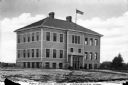
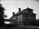
| Description: | View of a new multi-story school house as seen from across a lawn. The building features an American flag, two chimneys, and a walkway leading to a column... |
| Date: | |
|---|---|
| Description: | View of Central School. The brick building features arch windows and two chimneys. An enclosed bridge connects the building to another beside it and tree... |
| Date: | |
|---|---|
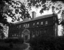
| Description: | A stone walkway leads to the entrance of the County Normal and Agricultural School. Ivy covers the exterior of the two-story colonial building and trees a... |

| Date: | 1925 |
|---|---|
| Description: | This 1925 map of Ashland County, Wisconsin, shows the township and range system, towns, sections, cities and villages, the Bad River Indian Reservation, ra... |

| Date: | 1970 |
|---|---|
| Description: | This pictorial map of Dunn County, Wisconsin, from the 1970s depicts historical events that occurred in the county. It shows cemeteries, churches, schools,... |

| Date: | 1873 |
|---|---|
| Description: | This 1873 map of Chippewa County, Wisconsin, which at the time also encompassed all or part of Price, Rusk, Sawyer, and Taylor counties, shows the township... |

| Date: | 1935 |
|---|---|
| Description: | This map shows railroads, telephone lines, roads, trails, schools, sub-agency, lookout stations, churches, community centers, and school site and farm. Bil... |

| Date: | 1936 |
|---|---|
| Description: | This map shows campsites, trails, auto roads, surrounding townships, and points of interest, by including pictorial illustrations. Includes an inserted map... |
If you didn't find the material you searched for, our Library Reference Staff can help.
Call our reference desk at 608-264-6535 or email us at:
