 Filter: Categories of Wisconsin Historical Images
Filter: Subject of education
Filter: Subject of streets
Filter: Subject of industries
Filter: Categories of Wisconsin Historical Images
Filter: Subject of education
Filter: Subject of streets
Filter: Subject of industries

| Date: | 1880 |
|---|---|
| Description: | Bird's-eye map over the Mississippi River of Fountain City. Paddle steamers and steamboats are on the river, and bluffs are in the background. |

| Date: | 1896 |
|---|---|
| Description: | Bird's-eye view of Washburn, with twenty vignettes around side, water in foreground with docks and lumber corral. Thirty-three locations identified in key ... |

| Date: | 1910 |
|---|---|
| Description: | Bird's-eye view looking east, with Washburn Harbor at center and Chequamegon Bay in Lake Superior covering most of the upper image. Streets with buildings... |

| Date: | 1874 |
|---|---|
| Description: | Bird's-eye view of Waukesha, looking southwest, with insets of State Industrial School, Court House, and Fountain Spring House. |
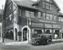
| Date: | 1937 |
|---|---|
| Description: | View across street of an International D-2 panel truck owned by the Troy Towel Supply Company parked outside Warner Beauty College. A man is walking on the... |

| Date: | 1909 |
|---|---|
| Description: | View across road of school children and a man and a woman standing in front of the two-story public school. There is a bell tower above the entrance. A num... |

| Date: | 1861 |
|---|---|
| Description: | This 1861 map of Columbia County, Wisconsin, shows the township and range grid, towns, sections, cities and villages, railroads, roads, property owners and... |

| Date: | 1889 |
|---|---|
| Description: | Shows city limits, railroads, mills, schools, cemeteries, dams, parks, lumber yards, log canals, log reservoir, Chippewa River, Eau Claire River, and Half ... |
| Date: | 1921 |
|---|---|
| Description: | View of men standing near a T-intersection. The three-story building on the left side of the intersection has a sandwich board advertising "Ice Cream." A m... |

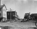
| Date: | 1922 |
|---|---|
| Description: | Elevated view taken from the roof of a building. Yards and dwellings in the foreground, with a church and school in the background. There are three or four... |
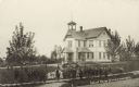
| Date: | |
|---|---|
| Description: | Slightly elevated view of a school with the students gathered on the board sidewalk. Adults are gathered near the front steps of the entrance to the school... |

| Date: | 1921 |
|---|---|
| Description: | This map of Racine is oriented with north to the right and shows labeled streets, Lake Michigan, and points of interest. There are manuscript annotations i... |

| Date: | 1859 |
|---|---|
| Description: | This map show plats including plat names, plat numbers, and some lot owner's names. Relief is shown by hachures. The map includes line drawings of Juneau B... |

| Date: | 1886 |
|---|---|
| Description: | This map has relief shown by hachures and includes a list of plats in order of date of record, laws which vacate plats, plats not shown as upon the county ... |

| Date: | 1888 |
|---|---|
| Description: | This map has relief shown by hachures and features inset maps of a plat of E.D. Clinton and Blackwell’s add’n to the City of La Crosse. Wards (1-10) shaded... |
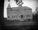
| Date: | 1897 |
|---|---|
| Description: | View across street towards the front of a large brick school building. Identified as the high school built in 1897 in Black River Falls. |

| Date: | |
|---|---|
| Description: | View down snowy road towards two large brick buildings. Identified as the schools in Black River Falls. |

| Date: | 1858 |
|---|---|
| Description: | This map is hand-colored and mounted on cloth and shows lot and block numbers and dimensions, landownership, streets, railroads, selected buildings, fair g... |
If you didn't find the material you searched for, our Library Reference Staff can help.
Call our reference desk at 608-264-6535 or email us at:

