Filter: Categories of Wisconsin Historical Images
Filter: Subject of education
Filter: Subject of roads
Filter: Categories of Wisconsin Historical Images
Filter: Subject of education
Filter: Subject of roads

| Date: | 1891 |
|---|---|
| Description: | Bird's-eye map of Wausau, looking north with ninety-eight businesses, industries, churches, schools, and civic buildings identified in location key below i... |
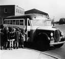
| Date: | |
|---|---|
| Description: | International school bus dropping children off along the side of a road. |

| Date: | 1870 |
|---|---|
| Description: | Baraboo was first settled around 1838, and by 1870 it had become the county seat and the thriving village illustrated here. This birds eye drawing depicts ... |

| Date: | 1876 |
|---|---|
| Description: | Bird's-eye view of Middleton with an inset of a school house. |

| Date: | 1867 |
|---|---|
| Description: | Birds-eye drawing of Beaver Dam, Dodge Co., depicting street names and street layout, houses, rivers, lakes, and trees. A reference key at the bottom of th... |

| Date: | 1890 |
|---|---|
| Description: | Bird's-eye map of Beloit with insets of Williams Engine Works, Eclipse Wind Engine Co., and John Foster & Co. Turtle Creek is in the lower section, and the... |

| Date: | 1869 |
|---|---|
| Description: | Birds-eye drawing of Boscobel, Grant County, depicts street names and street layouts, houses, rivers and trees. A reference key at the bottom of the map sh... |

| Date: | 1867 |
|---|---|
| Description: | Bird's-eye map of La Crosse with nine insets of residences, schools, and the Court House and Jail. |
| Date: | 1848 |
|---|---|
| Description: | Sketch of the Madison Women's Seminary on the corner of Wisconsin Avenue and East Johnson. The Madison Female Academy was a 19th century school for girls w... |

| Date: | 1875 |
|---|---|
| Description: | Bird's-eye map of Black River Falls, looking southwest. |

| Date: | 1872 |
|---|---|
| Description: | Birds-eye drawing of Eau Claire depicts street names and street locations, houses, trees, bridges, piers, canals, railroads, and the Chippewa and Eau Clair... |

| Date: | 1874 |
|---|---|
| Description: | Bird's-eye map of Lodi, with inset of Public School. Includes index of churches and points of interest. |
| Date: | 02 15 1939 |
|---|---|
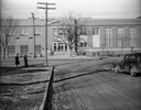
| Description: | View of Regent Street side of West High School from Vista Road. |
| Date: | 06 10 1935 |
|---|---|
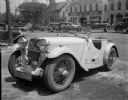
| Description: | Damaged English Singer sports car on the street, E. Washington Avenue, with Brayton School in the background. |
| Date: | 03 20 1931 |
|---|---|
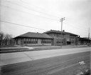
| Description: | Exterior view of the Nakoma Elementary School, located at 3870 Nakoma Road. |
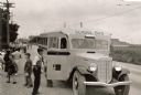
| Date: | 05 15 1926 |
|---|---|
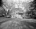
| Description: | Phi Gamma Delta fraternity house, located at 521 North Henry Street, with Royal Rapid Transit Co. buses. |
If you didn't find the material you searched for, our Library Reference Staff can help.
Call our reference desk at 608-264-6535 or email us at: