 Filter: Categories of Wisconsin Historical Images
Filter: Subject of education
Filter: Subject of rivers
Filter: Categories of Wisconsin Historical Images
Filter: Subject of education
Filter: Subject of rivers

| Date: | 1870 |
|---|---|
| Description: | Baraboo was first settled around 1838, and by 1870 it had become the county seat and the thriving village illustrated here. This birds eye drawing depicts ... |

| Date: | 1867 |
|---|---|
| Description: | Birds-eye drawing of Beaver Dam, Dodge Co., depicting street names and street layout, houses, rivers, lakes, and trees. A reference key at the bottom of th... |

| Date: | 1890 |
|---|---|
| Description: | Bird's-eye map of Beloit with insets of Williams Engine Works, Eclipse Wind Engine Co., and John Foster & Co. Turtle Creek is in the lower section, and the... |

| Date: | 1867 |
|---|---|
| Description: | Bird's-eye map of Berlin, with insets of West Side Public School and High School. |

| Date: | 1869 |
|---|---|
| Description: | Birds-eye drawing of Boscobel, Grant County, depicts street names and street layouts, houses, rivers and trees. A reference key at the bottom of the map sh... |

| Date: | 1868 |
|---|---|
| Description: | This 1868 birds-eye view depicts the buildings, streets, railroad, vegetation and topography of Columbus, Wisconsin. The high school, cemetery, railroad de... |

| Date: | 1867 |
|---|---|
| Description: | Bird's-eye map of Green Bay and Fort Howard, Brown Co., depicts street names and street layouts, houses, trees, and the East River. A reference key at the ... |

| Date: | 1870 |
|---|---|
| Description: | Bird's-eye map of Hudson, with insets of Court House and Public School. |

| Date: | 1874 |
|---|---|
| Description: | Bird's-eye view of Beloit, with insets of Beloit College, Beloit High School, and Memorial Hall. |

| Date: | 1875 |
|---|---|
| Description: | Bird's-eye map of Black River Falls, looking southwest. |

| Date: | 1872 |
|---|---|
| Description: | Birds-eye drawing of Eau Claire depicts street names and street locations, houses, trees, bridges, piers, canals, railroads, and the Chippewa and Eau Clair... |

| Date: | 1874 |
|---|---|
| Description: | Bird's-eye map of Lodi, with inset of Public School. Includes index of churches and points of interest. |
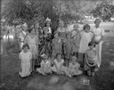
| Date: | 07 18 1932 |
|---|---|
| Description: | Marquette School children, with their drama teacher Ethel Kaump, in costumes for their play "The Fairy Woods," presented on the banks of the Yahara River. |

| Date: | 1874 |
|---|---|
| Description: | Bird's-eye view of Waukesha, looking southwest, with insets of State Industrial School, Court House, and Fountain Spring House. |

| Date: | 1910 |
|---|---|
| Description: | Chippewa Falls from the south side of the river below the falls. Includes the Sheely House Tavern, railway buildings, box cars, a train with five passenger... |

| Date: | 1931 |
|---|---|
| Description: | Aerial view looking north, with a small portion of the West Side (left), nearly all of the North Side and part of the business district of the East Side. A... |
If you didn't find the material you searched for, our Library Reference Staff can help.
Call our reference desk at 608-264-6535 or email us at:


