 Filter: Categories of Wisconsin Historical Images
Filter: Subject of education
Filter: Subject of railroad stations
Filter: Categories of Wisconsin Historical Images
Filter: Subject of education
Filter: Subject of railroad stations

| Date: | 1868 |
|---|---|
| Description: | This 1868 birds-eye view depicts the buildings, streets, railroad, vegetation and topography of Columbus, Wisconsin. The high school, cemetery, railroad de... |
| Date: | |
|---|---|
| Description: | A dinner station on the stage line from the railroad to the Uintah school, part of the Uintah and Ouray Agency. |

| Date: | 1905 |
|---|---|
| Description: | Multiple views of Haugen, including a church, a school with a group of students posed outside, and a locomotive at the railroad station, etc. Caption at to... |

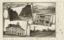
| Date: | 1905 |
|---|---|
| Description: | Clockwise from upper left images include: Cutters Point, Long Lake, Wis.; M.E. Church, New Auburn, Wis.; Farmers Store, New Auburn, Wis.; Public School, Ne... |
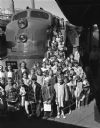
| Date: | 05 03 1948 |
|---|---|
| Description: | Youngsters from the Lakewood and Waunakee grade schools shown with the "Train of Tomorrow" at the North Western depot. The train was built for General Moto... |
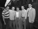
| Date: | 06 29 1948 |
|---|---|
| Description: | Five Madison recent high school graduates prior to traveling to Chicago for entrance into the U.S. Navy under the high school training program. From left a... |

| Date: | 02 14 1915 |
|---|---|
| Description: | A group of speakers, six men and two women, from the Alabama Crop Diversification Campaign, stand outside a building, probably a train station, marked with... |

| Date: | 02 26 1915 |
|---|---|
| Description: | A brass band led by W.F. Casey, standing at left, welcomes four Alabama Crop Diversification Campaign speakers at a train depot. A train and several buildi... |

| Date: | |
|---|---|
| Description: | A map that shows the Wisconsin Central Railway land grant lands for sale by the Soo Line, the Chicago, Milwaukee, and St. Paul Railway. Town sections, lak... |

| Date: | 1886 |
|---|---|
| Description: | A hand-colored map of Milwaukee County, Wisconsin that shows the township and range system, sections, towns, roads, railroads and rail stations, cities and... |

| Date: | 1891 |
|---|---|
| Description: | A hand-colored map of Milwaukee County, Wisconsin that shows the township and range system, sections, towns, roads, railroads and rail stations, cities and... |

| Date: | 1902 |
|---|---|
| Description: | A map of Milwaukee County, Wisconsin that shows the township and range system, sections, towns, roads, railroads and rail stations, cities and villages, po... |

| Date: | 1899 |
|---|---|
| Description: | This 1899 map of Douglas County, Wisconsin, shows the township and range grid, towns, sections, cities, villages and railroad stations, mines, roads, railr... |

| Date: | 1898 |
|---|---|
| Description: | Map showing the contour depths of the lakes in northwestern Waukesha County, Wisconsin. Roads, railroads, depots, churches, schools, and hotels in the area... |

| Date: | 1896 |
|---|---|
| Description: | This 1896 map of Douglas County, Wisconsin, shows the township and range grid, the towns of Superior, Brule, Gordon, and Nebagamain, sections, cities and v... |

| Date: | 1903 |
|---|---|
| Description: | Map shows railroads, roads, street car lines, schools, churches, cemeteries, town halls, and railroad stations. Includes inset lists of: Population of Milw... |
| Date: | 1905 |
|---|---|
| Description: | Photographic postcard of a collage of 5 views of Brandon including; Washington St., Public Square, Times Office, High School, and Depot & Park. |

| Date: | 1878 |
|---|---|
| Description: | This bird’s-eye-view map of Barton is indexed for parochial and public schools, churches, a convent, the railroad depot, and the post office. |

| Date: | 1927 |
|---|---|
| Description: | This map includes an index and highways marked in red. Attractions on the map include: Four Mile House, Cold Springs, Grand Crossing Station, Coleman Sloug... |
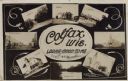
| Date: | 11 16 1908 |
|---|---|
| Description: | Photographic COLLAGE postcard of scenes of Colfax. In the center oval is the text, "Colfax, Wis. Looks Good To Me," however the "Looks Good To Me" is cross... |
If you didn't find the material you searched for, our Library Reference Staff can help.
Call our reference desk at 608-264-6535 or email us at: