 Filter: Categories of Wisconsin Historical Images
Filter: Subject of education
Filter: Subject of mounds
Filter: Categories of Wisconsin Historical Images
Filter: Subject of education
Filter: Subject of mounds
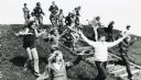
| Date: | 06 1973 |
|---|---|
| Description: | Fifth-graders from Mayville Public School celebrate the end of the school year by running down the earthen mounds at Aztalan State Park. Teachers on the tr... |

| Date: | 1970 |
|---|---|
| Description: | This pictorial map of Dunn County, Wisconsin, from the 1970s depicts historical events that occurred in the county. It shows cemeteries, churches, schools,... |

| Date: | 1859 |
|---|---|
| Description: | Shows townships and sections, landownership, roads, railroads, rural residences, schools, churches, and topography. Relief shown by hachures. "From governm... |

| Date: | 1861 |
|---|---|
| Description: | This map shows townships and sections, landownership, roads, railroads, rural residences, schools, churches, and topography. Also included are inset maps o... |

| Date: | 05 23 1958 |
|---|---|
| Description: | Construction begins on Spring Harbor School, 1110 Spring Harbor Drive just north of University Avenue. The building was designed by Kaeser and McLeod Archi... |

| Date: | 1944 |
|---|---|
| Description: | Portage County Map. Includes the towns of Eau Plaine, Dewey, Sharon, Alban, Carson, Hull, New Hope, Linwood, Stockton, Amherst, Plover, Grant, Buena Vista,... |
If you didn't find the material you searched for, our Library Reference Staff can help.
Call our reference desk at 608-264-6535 or email us at: