 Filter: Categories of Wisconsin Historical Images
Filter: Subject of education
Filter: Subject of indian reservations
Filter: Categories of Wisconsin Historical Images
Filter: Subject of education
Filter: Subject of indian reservations
| Date: | |
|---|---|
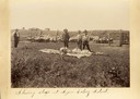
| Description: | Three men shear sheep at the Seger Colony School as one looks on. |
| Date: | 1902 |
|---|---|
| Description: | A Pyramid Lake Agency schoolhouse for Indian children. |
| Date: | |
|---|---|
| Description: | Children outdoors for recess at the Lower Cut Meat Creek School, part of the Rosebud Agency. |
| Date: | 1929 |
|---|---|
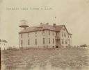
| Description: | The Government Indian School in Keshena. |
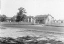
| Date: | 1929 |
|---|---|
| Description: | The U.S. Department of the Interior, Keshena Indian School. |
| Date: | 1936 |
|---|---|
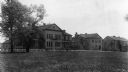
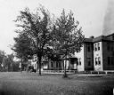
| Description: | St. Joseph's Indian School on the Keshena Menominee Reservation. |

| Date: | 1935 |
|---|---|
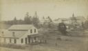
| Description: | Menominee Indian Reservation Government School near Shawano. Caption reads: "Government School, Menominee Indian Reservation, Near Shawano, Wis." |

| Date: | 1890 |
|---|---|
| Description: | Stereograph of Presbyterian Mission school grounds in the Chippewa Indian reservation. Building in background, boy walking in field in foreground. |

| Date: | 1890 |
|---|---|
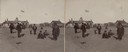
| Description: | Stereograph of Presbyterian Mission school. People gathered in front of building. Fence in foreground of photograph. |

| Date: | 1885 |
|---|---|
| Description: | Stereograph. Probably the Presbyterian Mission School grounds on the Chippewa Indian reservation. Two boys and a dog are standing in the foreground, with a... |
| Date: | 1890 |
|---|---|
| Description: | Farmer's house with rear of the government Contract School on the Menominee reservation in the distance. The Keshena Creek flows between the farmhouse and ... |

| Date: | 1939 |
|---|---|
| Description: | This map shows the towns to Gingles, Sanborn, and Guney as well as Chequamegon Bay, Kakagon River, White River, Marengo River, Bad River, Potato River, Vau... |

| Date: | 1880 |
|---|---|
| Description: | A hand-colored map of the Chippewa, Price, Taylor and the northern part of Clark counties, which shows the locations of farmhouses, schoolhouses, churches,... |

| Date: | 1896 |
|---|---|
| Description: | A map of Iron County, Wisconsin, shows vacant Wisconsin Central Rail Road lands, settlers houses, land sold by Wisconsin Central R.R., schools, churches, s... |

| Date: | 1898 |
|---|---|
| Description: | A map of Iron County, Wisconsin, shows vacant Wisconsin Central Rail Road lands, settlers houses, land sold by Wisconsin Central R.R., schools, churches, s... |

| Date: | |
|---|---|
| Description: | A map that shows the Wisconsin Central Railway land grant lands for sale by the Soo Line, the Chicago, Milwaukee, and St. Paul Railway. Town sections, lak... |

| Date: | 1920 |
|---|---|
| Description: | This map of Sawyer County, Wisconsin, from the early 20th century shows the township and range system, towns, sections, cities and villages, railroads, hig... |

| Date: | 1897 |
|---|---|
| Description: | This 1897 map of Sawyer County, Wisconsin, shows the township and range system, sections, roads, farm houses, camps, school houses, dams, bridges, Indian r... |

| Date: | 1898 |
|---|---|
| Description: | This 1898 map of Sawyer County, Wisconsin, shows the township and range system, sections, roads, farm houses, camps, school houses, dams, bridges, Indian r... |

| Date: | 1900 |
|---|---|
| Description: | This map of Sawyer County, Wisconsin, shows the numbered "sub-school-districts of the town of Hayward" school houses, and the Indian reservation. The towns... |
If you didn't find the material you searched for, our Library Reference Staff can help.
Call our reference desk at 608-264-6535 or email us at: