 Filter: Categories of Wisconsin Historical Images
Filter: Subject of education
Filter: Subject of fishing
Filter: Categories of Wisconsin Historical Images
Filter: Subject of education
Filter: Subject of fishing
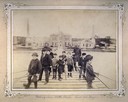
| Date: | 1893 |
|---|---|
| Description: | Group of young boys and two adult men fishing near the Water Works of the State Industrial School for Boys. |

| Date: | |
|---|---|
| Description: | A woman (possible Leny Vanbrink) pretending as though she was fishing in a bucket as part of a CIO activity at Highlander Folk School. Three people stand b... |

| Date: | 1939 |
|---|---|
| Description: | This map shows the towns to Gingles, Sanborn, and Guney as well as Chequamegon Bay, Kakagon River, White River, Marengo River, Bad River, Potato River, Vau... |
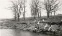
| Date: | 1931 |
|---|---|
| Description: | View across water towards a group of pupils from the Dyer School fishing from the banks of a stream "about a mile south of school." They are using long can... |

| Date: | 1908 |
|---|---|
| Description: | This map shows counties, roads, Lake Superior, Lake Michigan, and portions of surrounding states. Also included is a list of railroads showing miles and g... |

| Date: | 1910 |
|---|---|
| Description: | This map shows counties, roads, Lake Superior, Lake Michigan, and portions of surrounding states. Also included is a list of railroads showing miles and gr... |

| Date: | 1980 |
|---|---|
| Description: | This map shows schools, hotels, stations, roads, railroads, reefs, and public buildings. The upper right corner includes "A Summer and Winter Guide for Spo... |

| Date: | 1970 |
|---|---|
| Description: | This map shows roads, parks, swimming beaches, golf courses, yacht harbors, light houses, airports, public hunting grounds, waysides, schools, and fishing ... |

| Date: | 1936 |
|---|---|
| Description: | This map shows campsites, trails, auto roads, surrounding townships, and points of interest, by including pictorial illustrations. Includes an inserted map... |

| Date: | 1874 |
|---|---|
| Description: | Birds-eye view of Appleton Wisconsin. In the foreground are people fishing, strolling, and looking over the canal towards the Fox River. Streets and buildi... |

| Date: | 1962 |
|---|---|
| Description: | This colored map represents "Tour #2" of a series of driving tours of the state published by the Sperry & Hutchinson Company, in order to "help you enjoy W... |

| Date: | 1962 |
|---|---|
| Description: | This colored map represents "Tour #1" of a series of driving tours of the state published by the Sperry & Hutchinson Company, in order to "help you enjoy W... |

| Date: | 05 1904 |
|---|---|
| Description: | Miss McDonald, Jeannette Holt, and Alfred Holt are going fishing. Standing on the wooden sidewalk, they are holding long bamboo fishing poles over their sh... |
If you didn't find the material you searched for, our Library Reference Staff can help.
Call our reference desk at 608-264-6535 or email us at: