 Filter: Categories of Wisconsin Historical Images
Filter: Subject of education
Filter: Subject of courthouses
Filter: Categories of Wisconsin Historical Images
Filter: Subject of education
Filter: Subject of courthouses

| Date: | 1870 |
|---|---|
| Description: | Baraboo was first settled around 1838, and by 1870 it had become the county seat and the thriving village illustrated here. This birds eye drawing depicts ... |

| Date: | 1867 |
|---|---|
| Description: | Bird's-eye map of Green Bay and Fort Howard, Brown Co., depicts street names and street layouts, houses, trees, and the East River. A reference key at the ... |

| Date: | 1870 |
|---|---|
| Description: | Bird's-eye map of Hudson, with insets of Court House and Public School. |

| Date: | 1867 |
|---|---|
| Description: | Bird's-eye map of La Crosse with nine insets of residences, schools, and the Court House and Jail. |

| Date: | 1868 |
|---|---|
| Description: | Bird's-eye map of Portage, with insets of the Court House and the Public School. |

| Date: | 1875 |
|---|---|
| Description: | Bird's-eye map of Black River Falls, looking southwest. |

| Date: | 1896 |
|---|---|
| Description: | Bird's-eye view of Washburn, with twenty vignettes around side, water in foreground with docks and lumber corral. Thirty-three locations identified in key ... |

| Date: | 1874 |
|---|---|
| Description: | Bird's-eye view of Waukesha, looking southwest, with insets of State Industrial School, Court House, and Fountain Spring House. |
| Date: | 1890 |
|---|---|
| Description: | Elevated view. The church in the left background is the Zion Lutheran Church. The white house behind the bandstand is Captain Leahy's home (father of Admir... |

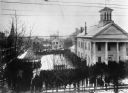
| Date: | 1908 |
|---|---|
| Description: | View of the courthouse and school building. Caption reads: "Court House and School Bldg., Sturgeon Bay, Wis." |

| Date: | |
|---|---|
| Description: | Elevated view across the tree lined city park towards the high school, courthouse, and bandstand. |

| Date: | |
|---|---|
| Description: | Bird's-eye view of the north branch extension canal on the Susquehanna river, surrounded by smaller renderings of structures of interest around the town in... |

| Date: | 03 15 1906 |
|---|---|
| Description: | Picture postcard view of the Buffalo County Court House and Buffalo County Training School. |

| Date: | 1947 |
|---|---|
| Description: | Shows lot and block numbers, 28 points of interest in the upper left that correspond to numbers on the map, and landownership with acreages. "Erickson Brot... |
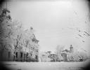
| Date: | |
|---|---|
| Description: | View towards trees and buildings lining a snow-covered city street. Location identified as Third Street in Black River Falls, the Jackson County Courthouse... |

| Date: | 06 1959 |
|---|---|
| Description: | This blue line print map shows lot and block numbers and dimensions, fair grounds, schools, court house, parks, and the street numbering system. The Crawfi... |
If you didn't find the material you searched for, our Library Reference Staff can help.
Call our reference desk at 608-264-6535 or email us at: