 Filter: Categories of Wisconsin Historical Images
Filter: Subject of education
Filter: Subject of bridges
Filter: Categories of Wisconsin Historical Images
Filter: Subject of education
Filter: Subject of bridges

| Date: | 1890 |
|---|---|
| Description: | Bird's-eye map of Beloit with insets of Williams Engine Works, Eclipse Wind Engine Co., and John Foster & Co. Turtle Creek is in the lower section, and the... |

| Date: | 1868 |
|---|---|
| Description: | This 1868 birds-eye view depicts the buildings, streets, railroad, vegetation and topography of Columbus, Wisconsin. The high school, cemetery, railroad de... |

| Date: | 1867 |
|---|---|
| Description: | Bird's-eye map of Green Bay and Fort Howard, Brown Co., depicts street names and street layouts, houses, trees, and the East River. A reference key at the ... |

| Date: | 1867 |
|---|---|
| Description: | Bird's-eye map of La Crosse with nine insets of residences, schools, and the Court House and Jail. |

| Date: | 1868 |
|---|---|
| Description: | Bird's-eye map of Portage, with insets of the Court House and the Public School. |

| Date: | 1875 |
|---|---|
| Description: | Bird's-eye map of Black River Falls, looking southwest. |

| Date: | 1872 |
|---|---|
| Description: | Birds-eye drawing of Eau Claire depicts street names and street locations, houses, trees, bridges, piers, canals, railroads, and the Chippewa and Eau Clair... |

| Date: | 1874 |
|---|---|
| Description: | Bird's-eye map of Lodi, with inset of Public School. Includes index of churches and points of interest. |

| Date: | 1874 |
|---|---|
| Description: | Bird's-eye view of Waukesha, looking southwest, with insets of State Industrial School, Court House, and Fountain Spring House. |

| Date: | 1879 |
|---|---|
| Description: | This map is a bird's-eye view of Wausau, the County Seat of Marathon County. The map features an index of points of interest. |
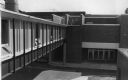
| Date: | 12 19 1971 |
|---|---|
| Description: | An overpass connecting two school buildings at West High School at 309 Ash Street. |
| Date: | 1910 |
|---|---|
| Description: | Exterior view of Hillside Home School with a bridge in the foreground. |
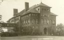
| Date: | 1915 |
|---|---|
| Description: | The Central School, later a part of Stout State College. Caption reads: "Central School, Menomonie, Wis." |
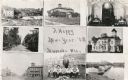
| Date: | 1909 |
|---|---|
| Description: | Composite of views of Muscoda including: Electric Light plant, Smalley House, St. John Catholic Church, Lover's Lane, Muscoda Public School, Wisconsin Aven... |
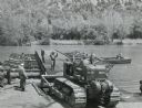
| Date: | 1958 |
|---|---|
| Description: | Soldier using an International TD-18 crawler tractor (TracTracTor) during a training exercise. The original caption reads: "A graduate of the school assign... |

| Date: | 05 13 1950 |
|---|---|
| Description: | Three teenage girls are carrying shovels on their shoulders while crossing a wooden foot bridge. More than 150 Madison high school pupils recruited throug... |
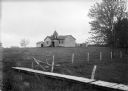
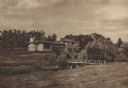
| Date: | |
|---|---|
| Description: | View over wooden bridge of school building. There is a ladder near the front entrance which has a small bell tower. There is a shed on the left, and an ou... |
If you didn't find the material you searched for, our Library Reference Staff can help.
Call our reference desk at 608-264-6535 or email us at:


