 Filter: Categories of Wisconsin Historical Images
Filter: Subject of education
Filter: County of Milwaukee
Filter: Categories of Wisconsin Historical Images
Filter: Subject of education
Filter: County of Milwaukee
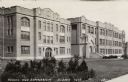
| Date: | 1943 |
|---|---|
| Description: | Photographic postcard view of brick school and gymnasium buildings. Caption reads: "School and Gymnasium, Cudahy, Wis." |
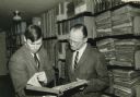
| Date: | 03 1965 |
|---|---|
| Description: | The caption with this photograph reads: "Dr. Walter Peterson (right), professor of history at Lawrence University, Appleton, with F. Gerald Ham, Wisconsin ... |

| Date: | 1857 |
|---|---|
| Description: | This map shows lot and block numbers, wards, roads, railroads, some landowners’ names, and selected buildings. The map includes an inset map of Glidden & L... |

| Date: | 1857 |
|---|---|
| Description: | This map shows lot and block numbers, wards, roads, railroads, some landowners’ names, and selected buildings. Lake Michigan, the Milwaukee River, and Glid... |

| Date: | 1857 |
|---|---|
| Description: | This map shows lot and block numbers, wards, roads, railroads, some landowners’ names, and selected buildings. Lake Michigan, the Milwaukee River, and Glid... |

| Date: | 1892 |
|---|---|
| Description: | This map shows schools, engine houses, railroads, street railways, wards, parks, cemeteries, block numbers, a street index, explanations, and general refer... |

| Date: | 1901 |
|---|---|
| Description: | This map shows public schools, engine houses, railroads, street railways, city wards, parks, block numbers, and Lake Michigan. Also included are indexes, t... |

| Date: | 1965 |
|---|---|
| Description: | This map shows wards, city limits, railroad right of way, proposed future streets, and approximate street elevations. Wards and public schools are labeled ... |

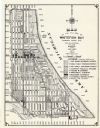
| Date: | 1904 |
|---|---|
| Description: | This map has three inset maps of Whitefish Bay, Cudahy, and South Milwaukee. This map depicts schools, engine houses, railroads, street railways, city ward... |

| Date: | 1960 |
|---|---|
| Description: | This blue line print shows state and city maintained roads, as well as government land, parks, Milwaukee Co. Park Commission, golf courses, schools, City o... |

| Date: | 1904 |
|---|---|
| Description: | This map shows wards, schools, engine houses, railroads, street railways, block numbers, parks, roads, and Lake Michigan. Also included are indexes: Table ... |
| Date: | 1965 |
|---|---|
| Description: | This map shows 8 zoning districts, as well as house number system, schools, parks, churches, and points of interest. Lake Michigan is labeled and the lower... |

| Date: | 1924 |
|---|---|
| Description: | This map shows streets, selected buildings, railroads, railway yards, schools, parks, schools, cemeteries, bays, the Milwaukee River, and Lake Michigan. De... |

| Date: | 1927 |
|---|---|
| Description: | This map shows street car lines, bus routes, railroads, proposed city boundary lines, wards, public schools, blocks & house numbers, Lake Michigan, one mil... |

| Date: | 1910 |
|---|---|
| Description: | A Sanborn insurance map of Milwaukee, including the shore of Lake Michigan. |

| Date: | |
|---|---|
| Description: | View from back of classroom towards Vel Phillips standing behind a desk. The chalkboard behind her reads: "Protective" and "Public Works." There is a map o... |

| Date: | 1956 |
|---|---|
| Description: | This map shows city, suburban, parochial and other types schools, with an explanation of symbols in the right margin. The original caption for the map read... |

| Date: | 1966 |
|---|---|
| Description: | This map shows city, suburban, parochial and other types schools, with an explanation of symbols in the right margin. The original caption for the map read... |
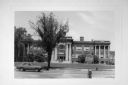
| Date: | |
|---|---|
| Description: | Exterior view from across street of Atwater School at 2100 North Capitol Drive. There are several people on the school front steps. A car is driving on the... |

| Date: | 1900 |
|---|---|
| Description: | This map shows landownership, railroads, roads, churches, schools, cemeteries, post offices, townships, city wards, Lake Michigan, and rivers. The map incl... |
If you didn't find the material you searched for, our Library Reference Staff can help.
Call our reference desk at 608-264-6535 or email us at: