 Filter: Categories of Wisconsin Historical Images
Filter: Subject of education
Filter: County of Milwaukee
Filter: Categories of Wisconsin Historical Images
Filter: Subject of education
Filter: County of Milwaukee

| Date: | 1891 |
|---|---|
| Description: | A hand-colored map of Milwaukee County, Wisconsin that shows the township and range system, sections, towns, roads, railroads and rail stations, cities and... |

| Date: | 1896 |
|---|---|
| Description: | A map of Milwaukee County, Wisconsin that shows the township and range system, sections, towns, roads, railroads and rail stations, cities and villages, po... |

| Date: | 1902 |
|---|---|
| Description: | A map of Milwaukee County, Wisconsin that shows the township and range system, sections, towns, roads, railroads and rail stations, cities and villages, po... |

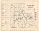
| Date: | 1976 |
|---|---|
| Description: | A street map of Milwaukee County, Wisconsin that identifies the location of schools, hospitals, parks, beaches, streets, freeways, both planned or under co... |

| Date: | 1993 |
|---|---|
| Description: | A map of Milwaukee County, indicating the locations of toxic sites and the types of toxic sites, ranging from those listed as a superfund site, industry re... |

| Date: | 1863 |
|---|---|
| Description: | Includes index to public buildings, churches, schools. Inset: Glidden & Lockwood’s addition. Gives names of some property owners. |

| Date: | 05 1958 |
|---|---|
| Description: | Photocopy of a map created by the City of Milwaukee Master Plan Program City Planning Division in May of 1958 representing 1870 "THE CENTRAL AREA OF THE CI... |

| Date: | 1964 |
|---|---|
| Description: | A group of protesters march down a street, led by a car. They are protesting school segregation. |

| Date: | 1906 |
|---|---|
| Description: | Informal portrait of Katherine Morrissey Dodge Cook seated at a desk in front of a classroom full of students. |
| Date: | 04 21 1919 |
|---|---|
| Description: | Front cover, menu, and back cover of program ("Conferring the Service Stripes") for a dinner at the Medford Hotel, with a deep rose hand-colored border wit... |

| Date: | 1903 |
|---|---|
| Description: | Map shows railroads, roads, street car lines, schools, churches, cemeteries, town halls, and railroad stations. Includes inset lists of: Population of Milw... |

| Date: | 1960 |
|---|---|
| Description: | This map of Greedale shows local streets, parks, schools, and churches and includes manuscript annotations in green and blue showing tracts and parcels of ... |

| Date: | 1932 |
|---|---|
| Description: | This map of Granville shows streets, businesses, residential areas, schools, golf courses, and industrial areas. The map shows Granville in March of 1932. ... |

| Date: | 1957 |
|---|---|
| Description: | High school student, Judith Castine, leaning on a desk, studying at West Milwaukee High School. |

| Date: | 1938 |
|---|---|
| Description: | This map shows buildings, lots, parks, schools, pumping stations, sites reserved for churches, and water towers. |

| Date: | 1964 |
|---|---|
| Description: | This map is a hand-colored blue line print and shows 4 residence zones, 2 business zones, 1 light manufacturing zones, schools, and parks. The zones are ou... |
| Date: | 1965 |
|---|---|
| Description: | This map shows Milwaukee County Parkway lands, streets, streets not yet constructed, public facilities, schools, churches, and manufacturers. The map inclu... |

| Date: | 09 20 1989 |
|---|---|
| Description: | Melodie Albritton holds up an origami crane she folded at St. Nicholas School. |

| Date: | |
|---|---|
| Description: | Elevated view of students in a home economics kitchen classroom at Roosevelt Junior High. |

| Date: | 09 20 1989 |
|---|---|
| Description: | Janine Dagons resting her chin on a table with an origami peace crane sitting in front of her. |
If you didn't find the material you searched for, our Library Reference Staff can help.
Call our reference desk at 608-264-6535 or email us at: