 Filter: Categories of Wisconsin Historical Images
Filter: Subject of education
Filter: Community of Milwaukee
Filter: Year of 1900-1999
Filter: Year of 1900-1909
Filter: Categories of Wisconsin Historical Images
Filter: Subject of education
Filter: Community of Milwaukee
Filter: Year of 1900-1999
Filter: Year of 1900-1909

| Date: | 05 30 1904 |
|---|---|
| Description: | Chromolithograph of Old Abe, Wisconsin War Eagle. The title reads: "Memorial Day in Wisconsin Schools." |
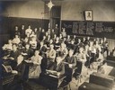
| Date: | 05 1909 |
|---|---|
| Description: | Slightly elevated view from front of students and teachers in an early 20th century school classroom. The names of all the students are written on the blac... |
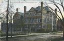
| Date: | 1905 |
|---|---|
| Description: | Exterior view across street toward the school on a street corner. The school building has five levels, with peaked roofs and several chimneys. A red buildi... |
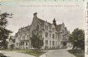
| Date: | 1906 |
|---|---|
| Description: | Administration building for the school. The building has over three stories, and a covered main entrance. Caption reads: "Administration Building, Industri... |
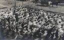
| Date: | 1909 |
|---|---|
| Description: | Elevated view of a large group of school children exercising in the schoolyard. Boys and girls are on separate sides of the yard. All are the students are ... |
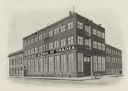
| Date: | 1906 |
|---|---|
| Description: | An exterior view of the Milwaukee School of Trades. |

| Date: | 1901 |
|---|---|
| Description: | Milwaukee Public school, Sixth district School no. 2, Fifth grade class. teacher Miss H. Kather, Patrick Shaunnessy Principal. Boys: Emil Dankert, Charles ... |

| Date: | 1902 |
|---|---|
| Description: | A map of Milwaukee County, Wisconsin that shows the township and range system, sections, towns, roads, railroads and rail stations, cities and villages, po... |

| Date: | 1901 |
|---|---|
| Description: | This map shows public schools, engine houses, railroads, street railways, city wards, parks, block numbers, and Lake Michigan. Also included are indexes, t... |

| Date: | 1904 |
|---|---|
| Description: | This map has three inset maps of Whitefish Bay, Cudahy, and South Milwaukee. This map depicts schools, engine houses, railroads, street railways, city ward... |

| Date: | 1904 |
|---|---|
| Description: | This map shows wards, schools, engine houses, railroads, street railways, block numbers, parks, roads, and Lake Michigan. Also included are indexes: Table ... |
If you didn't find the material you searched for, our Library Reference Staff can help.
Call our reference desk at 608-264-6535 or email us at: