 Filter: Categories of Wisconsin Historical Images
Filter: Subject of education
Filter: Type of Map or Atlas
Filter: Categories of Wisconsin Historical Images
Filter: Subject of education
Filter: Type of Map or Atlas

| Date: | 1859 |
|---|---|
| Description: | Shows townships and sections, landownership, roads, railroads, rural residences, schools, churches, and topography. Relief shown by hachures. "From governm... |

| Date: | 1900 |
|---|---|
| Description: | Shows lands belonging to Wisconsin Timber and Land Co., towns, post offices, saw mills, creameries, camps, churches, schools, farm houses, town halls, rail... |

| Date: | 1862 |
|---|---|
| Description: | Shows townships and sections, landownership and acreage, roads, railroads, churches, schools, and cemeteries. Inset maps: Plat of Hingham -- Plat of Casca... |
| Date: | 1911 |
|---|---|
| Description: | Shows routes, post offices, churches, houses, schools, roads, and collection boxes. "B. Oct. 11, 1911." Blue line print. "Sheboygan Co., Wis. 587." |

| Date: | 1966 |
|---|---|
| Description: | This 1966 map shows topography, roads, highways, golf courses, government buildings, and businesses around Delavan Lake in Walworth County, Wisconsin. Incl... |

| Date: | 1899 |
|---|---|
| Description: | This 1899 map of Dodge County, Wisconsin, shows the township and range grid, towns, sections, cities and villages, roads, railroads, post offices, cemeteri... |

| Date: | 1896 |
|---|---|
| Description: | This 1896 map of Douglas County, Wisconsin, shows the township and range grid, the towns of Superior, Brule, Gordon, and Nebagamain, sections, cities and v... |

| Date: | 11 26 1907 |
|---|---|
| Description: | Relief shown by hachures. Shows roads, railroads, schools, post offices, rivers, and lakes of Douglas County, and portions of Minnesota and Lake Superior. ... |

| Date: | 1930 |
|---|---|
| Description: | Shows county system of roads which are surfaced, well graded, common, or unimproved, town roads, state trunk highways, town and village boundaries, schools... |

| Date: | 1930 |
|---|---|
| Description: | Shows county system of roads which are surfaced, well graded, common, or unimproved, town roads, state trunk highways, town and village boundaries, schools... |

| Date: | 1911 |
|---|---|
| Description: | This 1911 map from the U.S. Post Office Department shows rural delivery routes, active and discontinued post offices, selected rural landowners and houses,... |

| Date: | 1858 |
|---|---|
| Description: | This 1858 map of Rock County, Wisconsin, shows the township and range grid, towns, sections, cities and villages, railroads, roads, property owners and res... |
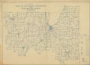
| Date: | 1911 |
|---|---|
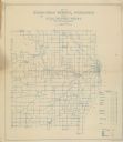
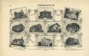
| Description: | "Standard Historical Atlas of Dane County, Wisconsin." Top half of page 98, showing all of the different district schools in Middleton. |
| Date: | 1911 |
|---|---|
| Description: | Shows roads, railroads, post offices, schools, houses, churches, routes, and collection boxes. Includes distant chart and explanation. "Price 35 cents"--... |
| Date: | 1910 |
|---|---|
| Description: | Shows roads, railroads, post offices, schools, houses, churches, and routes. Includes distant chart and explanation. "Price 35 cents"--Upper left margin. "... |

| Date: | 1928 |
|---|---|
| Description: | Shows different types of roads, railroads, schools, churches, farmsteads, cheese factories, mine shafts, old surface workings, streams, old sulphur pits, a... |

| Date: | 1911 |
|---|---|
| Description: | Shows roads, railroads, post offices, schools, houses, churches, and routes. Includes distant chart and explanation. "Price 35 cents"--Upper left margin. "... |
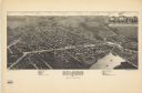
| Date: | 1884 |
|---|---|
| Description: | This map is a Birdseye view of Delavan, Wisconsin. At the bottom of the map are points of interest that correspond to numbers on the map. Many of the stree... |

| Date: | 1947 |
|---|---|
| Description: | Shows lot and block numbers, 28 points of interest in the upper left that correspond to numbers on the map, and landownership with acreages. "Erickson Brot... |

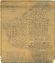
| Date: | 1863 |
|---|---|
| Description: | Includes index to public buildings, churches, schools. Inset: Glidden & Lockwood’s addition. Gives names of some property owners. |
If you didn't find the material you searched for, our Library Reference Staff can help.
Call our reference desk at 608-264-6535 or email us at: