 Filter: Categories of Wisconsin Historical Images
Filter: Subject of canals
Filter: County of Milwaukee
Filter: Categories of Wisconsin Historical Images
Filter: Subject of canals
Filter: County of Milwaukee

| Date: | 07 1959 |
|---|---|
| Description: | Dickey Chapelle, photographer, on the same Milwaukee beach where she learned to swim as a young girl. She was covering "Operation Inland Seas" celebrating ... |
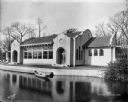
| Date: | 11 01 1916 |
|---|---|
| Description: | Pavilion at Kosciusko Park lagoon at W. Lincoln Avenue and S. 7th Street. A rowboat is floating in the lagoon. |
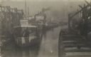
| Date: | 1905 |
|---|---|
| Description: | Canal with several ships, mostly small steam-engine cargo ships. |
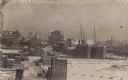
| Date: | 1900 |
|---|---|
| Description: | Two ships at the end of the canal, several buildings, a small lumberyard, and snow. Three other ships are visible down the canal. |
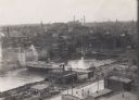
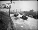
| Date: | 1910 |
|---|---|
| Description: | Elevated view from a building of a canal in the city, with a boat on the canal. A bridge is also visible. |
| Date: | |
|---|---|
| Description: | Elevated view of tugboat pulling a steamer caked in ice in a canal. Steam is rising from the water and an open drawbridge can be seen in the background. On... |

| Date: | 1878 |
|---|---|
| Description: | This map shows block numbers, wards, roads, railroads, parks, and selected buildings and includes a "Milwaukee city street guide" as well as a guide to pub... |

| Date: | 1837 |
|---|---|
| Description: | A pen and ink on tracing paper, hand-drawn and colored map the proposed route of the Milwaukee and Rock River Canal, ranging from the Rock River in the wes... |

| Date: | 1936 |
|---|---|
| Description: | Street map of the City of Milwaukee and surrounding suburbs indicating various mass transit lines. There is an index to Milwaukee streets at the right of t... |

| Date: | 1902 |
|---|---|
| Description: | This map is a chart of Milwaukee Harbor that displays local streets, bridges, roads, railroads, public buildings, businesses, factories, dry docks, parks, ... |

| Date: | 1907 |
|---|---|
| Description: | This map is a chart of Milwaukee Harbor that displays local streets, bridges, roads, railroads, public buildings, businesses, factories, dry docks, parks, ... |

| Date: | 1910 |
|---|---|
| Description: | This ink on paper blue line print base map consists of eight separate pieces and shows city limits, The Milwaukee Electric Railroad & Light Company lines, ... |

| Date: | 1887 |
|---|---|
| Description: | This map shows sewers, manholes, streets, canals, rivers, and Lake Michigan. An explanation of sewer types is included. |

| Date: | 2000 |
|---|---|
| Description: | This map shows the industrial area along the Menominee River and canals. Industrial buildings are shown in orange and labeled in red. Other areas are shown... |
If you didn't find the material you searched for, our Library Reference Staff can help.
Call our reference desk at 608-264-6535 or email us at: