 Filter: Categories of Wisconsin Historical Images
Filter: Subject of botany
Filter: Creator Name of Barnard, George N., 1819-1902
Filter: Categories of Wisconsin Historical Images
Filter: Subject of botany
Filter: Creator Name of Barnard, George N., 1819-1902
| Date: | 1866 |
|---|---|
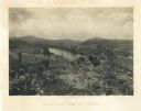
| Description: | View towards the Allatoona Pass from behind earthworks overlooking the Etawah River. A railroad bridge crosses the river on the right. Plate 24 |
| Date: | 1866 |
|---|---|
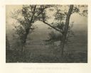
| Description: | A fence or battlement, with battered trees overlooking a valley. Kenesaw Mountain is in the distance. |
| Date: | 1866 |
|---|---|
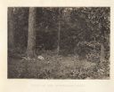
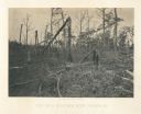
| Description: | A clearing in some trees with an animal skull where Union General McPherson died. Plate 35 |
| Date: | 1866 |
|---|---|
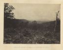
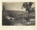
| Description: | Location of Sherman's attack at Chattanooga. There is a road, trees and shrubs in the foreground, overlooking a valley. Mountains are in the distance. P... |
| Date: | 1866 |
|---|---|
| Description: | View of Ringgold in the far distance. A tree and pile of rubble, perhaps the remains of a fireplace, in the foreground. Plate 17 |

| Date: | 1866 |
|---|---|
| Description: | View along earthworks overlooking the Etawah River and a railroad bridge. A tree stripped of branches and bark is on the left. Plate 23 |
| Date: | 1865 |
|---|---|
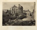
| Description: | Ruins of the Pinckney Mansion with rubble in the street after General Sherman's men burned the town near the end of the Civil War. Plate 59 |

| Date: | 1864 |
|---|---|
| Description: | One of the Confederate defenses around the city, with several cannons behind earthworks. A Union soldier stands near one of the cannons. Plate 40 |

| Date: | 1864 |
|---|---|
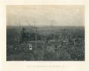
| Description: | View looking out from one of the Confederate defenses around the outside of the city. Wooden palisades surround the earthworks. Houses and other buildings ... |
| Date: | 1866 |
|---|---|
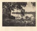
| Description: | Trees with Spanish moss along the Savannah River. Plate 47 |
| Date: | 1866 |
|---|---|
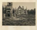
| Description: | The ruins of a church in Columbia after General Sherman's men burned the town near the end of the Civil War. Plate 54 |
| Date: | 1866 |
|---|---|
| Description: | Destruction of Columbia after General Sherman's men burned the town near the end of the Civil War. Plate 53 |
| Date: | 1866 |
|---|---|
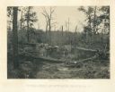
| Description: | Aftermath of the battle at New Hope, a hillside covered with broken and barren trees. Plate 27 |
| Date: | 1866 |
|---|---|
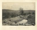
| Description: | An earth mound with some burlap sacks covering it. Many barren trees surround the scene. Plate 26 |
| Date: | 1866 |
|---|---|
| Description: | View from Mission Ridge of the valley floor where fighting took place. Plate 10 |
| Date: | 1866 |
|---|---|
| Description: | A rocky ridge with bushes and scrub atop Mission Ridge is in the foreground. Orchard Knob is in the distance. The valley where the fighting took place is i... |
| Date: | 1866 |
|---|---|
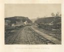
| Description: | View from railroad tracks through the Allatoona Pass. One of the buildings on the left says "Grocery," and piles of lumber are stacked along the sides of t... |
| Date: | 1866 |
|---|---|
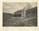
| Description: | Farmhouse with a large chimney and front porch. A group of people are sitting on the porch. The house was used as a hospital several times during the battl... |
| Date: | 1864 |
|---|---|
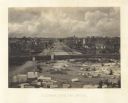
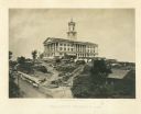
| Description: | The capitol building is on a hill overlooking the city. Union soldiers have pitched tents on the grounds. Plate 02 |
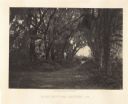
| Date: | 1866 |
|---|---|
| Description: | Trees with Spanish moss line a path in the Bonaventure Cemetery. Plate 48 |
If you didn't find the material you searched for, our Library Reference Staff can help.
Call our reference desk at 608-264-6535 or email us at: