 Filter: Categories of Wisconsin Historical Images
Filter: Subject of blueprints
Filter: Categories of Wisconsin Historical Images
Filter: Subject of blueprints

| Date: | 02 14 1939 |
|---|---|
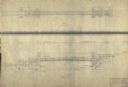
| Description: | Deatiled blueprint (pg 2) for the suspension footbridge in Copper Falls State Park. |
| Date: | 12 14 1939 |
|---|---|
| Description: | Page 1 of detailed blueprints for the suspension footbridge in Copper Falls State Park. |

| Date: | 02 12 1946 |
|---|---|
| Description: | Blueprints details for Signs and Markers for Copper Falls State Park. |

| Date: | 07 1957 |
|---|---|
| Description: | Blueprints for highway signs for Devil's Lake State Park. |
| Date: | 05 1936 |
|---|---|
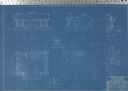
| Description: | Blueprint for Trail Shelter in Devil's Lake State Park. |
| Date: | 05 1936 |
|---|---|
| Description: | Blueprint showing the details for stone shelter in Devil's Lake State Park. |
| Date: | 02 08 1936 |
|---|---|
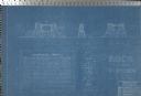
| Description: | Blueprints for the Signs and Markers for Devil's Lake State Park. |
| Date: | 05 27 1936 |
|---|---|
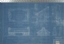
| Description: | Blueprints for the Bath House in Devil's Lake State Park. |

| Date: | 1945 |
|---|---|
| Description: | Factory worker Joan Harris sits at a workspace to inspect a 20 mm cannon bolt body part at International Harvester's St. Paul Works. Tools are on the table... |
| Date: | 08 1919 |
|---|---|
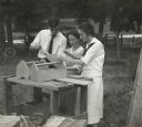
| Description: | Two women and one man, probably rural school teachers, are standing outdoors near a work bench, reviewing the blueprints to construct a nail box. |

| Date: | 1927 |
|---|---|
| Description: | Blueprint-style map of Frost Woods on the shore of Lake Monona. The map indicates the locations of Indian mounds, an Indian camp, and various plants. There... |
| Date: | 08 1948 |
|---|---|
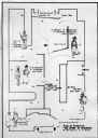
| Description: | Floor plan of the Wisconsin Historical Society's "Story of Wisconsin" exhibit at the Wisconsin Centennial Exposition. |

| Date: | |
|---|---|
| Description: | Blueprint of the formal garden for Stanley McCormick's Riven Rock estate at El Montecito, Santa Barbara, California. The blueprint was created by Shepley, ... |

| Date: | 1900 |
|---|---|
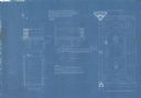
| Description: | Blueprint of the stone seat, outside elevation of Gate "Y," rear of fountain at end of basin, and elevation of Gate "Z" for Stanley McCormick's Riven Rock ... |

| Date: | 1900 |
|---|---|
| Description: | Blueprint showing the elevation of Gate "X" for Stanley McCormick's Riven Rock estate at El Montecito, Santa Barbara, California. The blueprint shows a vie... |

| Date: | 1897 |
|---|---|
| Description: | Topographical map of Stanley McCormick's Riven Rock estate in El Montecito, Santa Barbara County, California. The map is identified as a map of a survey co... |
| Date: | |
|---|---|
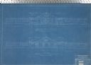
| Description: | A blueprint showing the second floor balcony outside of the linen room of Stanley McCormick's Riven Rock estate in El Montecito, Santa Barbara County, Cali... |

| Date: | 1900 |
|---|---|
| Description: | Blueprint showing the mantles at Stanley McCormick's Riven Rock estate in El Montecito, Santa Barbara County, California. The architectural firm is identif... |

| Date: | 1899 |
|---|---|
| Description: | Topographical map showing ridges, water courses, boundary lines, and trails and roads near the Stanley McCormick's Riven Rock estate in El Montecito, Santa... |

| Date: | 1899 |
|---|---|
| Description: | Map of the Santa Barbara Channel California area showing property boundaries and some geographical features. The Riven Rock Estate has been outlined in yel... |
If you didn't find the material you searched for, our Library Reference Staff can help.
Call our reference desk at 608-264-6535 or email us at: