 Filter: Categories of Wisconsin Historical Images
Filter: Subject of advertising
Filter: Subject of church buildings
Filter: Categories of Wisconsin Historical Images
Filter: Subject of advertising
Filter: Subject of church buildings
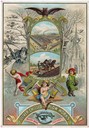
| Date: | 1883 |
|---|---|
| Description: | Lithographed advertising card for the Oliver Chilled Plow Works commemorating the new year, 1884. The card features two color illustrations within a gold f... |
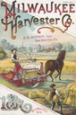
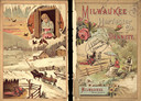
| Date: | 1887 |
|---|---|
| Description: | Cover of an advertising brochure for the Milwaukee Harvester Company featuring a color chromolithograph illustration of farmers in a field with a horse-dra... |

| Date: | 1885 |
|---|---|
| Description: | Bird's-eye map of Waupun on the Rock River. There is an inset at top center of "Althouse, Wheeler & Co., Windmills and Pumps." |

| Date: | 1965 |
|---|---|
| Description: | Front cover of an advertising brochure for International D-Line light-duty pickup trucks featuring color illustration of truck. |
| Date: | 04 1925 |
|---|---|
| Description: | A church is in the distance at the end of the road. On either side of the street are homes and stores, with a street light suspended above the street in t... |

| Date: | |
|---|---|
| Description: | Panoramic view of downtown at the intersection of 8th and Washington Streets. The Manitowoc County Courthouse is at the right. Residences and churches can ... |

| Date: | 1913 |
|---|---|
| Description: | A wall atlas of Sauk County, Wisconsin, displaying its 22 towns. On the left side are advertisements for local businesses. |
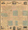
| Date: | 1886 |
|---|---|
| Description: | This 1886 map of Saint Croix County, Wisconsin, shows the township and range grid, sections, towns, cities and villages, land ownership and acreages, wagon... |

| Date: | 1905 |
|---|---|
| Description: | This early 20th century map of Door County, Wisconsin, shows the township and range grid, towns, sections, cities and villages, landownership and acreages,... |

| Date: | 1899 |
|---|---|
| Description: | This 1899 map of Dodge County, Wisconsin, shows the township and range grid, towns, sections, cities and villages, roads, railroads, post offices, cemeteri... |

| Date: | 1940 |
|---|---|
| Description: | Map features advertisements for local businesses on the left and bottom. Map includes a "LEGEND" and "DIRECTORY OF CHURCHES". Streets are labeled as are so... |

| Date: | 1914 |
|---|---|
| Description: | Includes index of University of Wisconsin buildings, churches, and public buildings. Top of Map reads: '"GET A SQUARE DEAL" AT THE COLLEGE BOOK STORE SHOWN... |
| Date: | 10 24 1930 |
|---|---|
| Description: | Man sitting in driver's seat of a Skelly Truck promoting itself with banners and streamers. In the background on the right is a church. |
| Date: | 1885 |
|---|---|
| Description: | The front cover features a color illustration of a man and woman relaxing near a lake or river. The woman is sitting on a chair under an umbrella painting ... |

| Date: | 1883 |
|---|---|
| Description: | Inside spread of advertising brochure for Patterson and Brothers, manufacturers of agricultural equipment, Patterson, Ontario, Canada. Features a chromolit... |

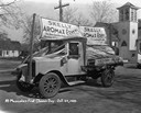
| Date: | 1923 |
|---|---|
| Description: | The Schoelkopf advertising truck parked on the street near the store at 210-216 E. Washington Avenue. The truck advertises a number of products: Rockway Sp... |

| Date: | 1919 |
|---|---|
| Description: | Two men in suits and hats pose outdoors near a Madison Auto Good Roads Highway Patrol vehicle parked at the curb. On the side of the truck are painted sign... |

| Date: | 2004 |
|---|---|
| Description: | This map shows ATMs, houses of worship, hotels, parking ramps, public parking, union cab stands, bus stops, business district, parks and public areas, gove... |
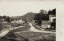
| Date: | 1908 |
|---|---|
| Description: | View of a street with a lumber office and a church on the left, and dwellings on the right. A man and a dog are on the sidewalk. A tree-covered hill is in ... |

| Date: | |
|---|---|
| Description: | Elevated view of central Janesville from the the courthouse. There are signs advertising Parker Pens and Coca-Cola. Churches are on the horizon. Caption re... |
If you didn't find the material you searched for, our Library Reference Staff can help.
Call our reference desk at 608-264-6535 or email us at: