 Filter: Categories of Wisconsin Historical Images
Filter: Subject of advertising
Filter: Type of Map or Atlas
Filter: Subject of water
Filter: Categories of Wisconsin Historical Images
Filter: Subject of advertising
Filter: Type of Map or Atlas
Filter: Subject of water

| Date: | 1930 |
|---|---|
| Description: | Page 8 of the 1930 schedule is a map of the routes of the Goodrich Steamship Lines in Lake Michigan and Lake Huron. |

| Date: | 1885 |
|---|---|
| Description: | Bird's-eye map of Waupun on the Rock River. There is an inset at top center of "Althouse, Wheeler & Co., Windmills and Pumps." |

| Date: | 1898 |
|---|---|
| Description: | Shows railway lines in Wisconsin marked in red and counties in colors. The meridians are Greenwich, Wisconsin and Washington, Wisconsin. The map folds into... |

| Date: | 1913 |
|---|---|
| Description: | A wall atlas of Sauk County, Wisconsin, displaying its 22 towns. On the left side are advertisements for local businesses. |

| Date: | 1920 |
|---|---|
| Description: | A two-sided map of the state of Wisconsin. The front includes towns and major cities as well as state and county trunk highways. The back includes a smalle... |

| Date: | 1949 |
|---|---|
| Description: | This color map includes historical descriptions of select areas and a short article on the history of Wisconsin. The major highways in the state shown on t... |

| Date: | 1923 |
|---|---|
| Description: | This map shows trails, some in red, for automobiles. The right margin includes a key of markings as well as Minnesota and Wisconsin Highway signs. Communit... |

| Date: | 1904 |
|---|---|
| Description: | A brochure for the lake region of north-eastern Illinois and south-eastern Wisconsin providing information on summer activities and places to stay in the a... |

| Date: | 1903 |
|---|---|
| Description: | This map of Richland County, Wisconsin, shows land ownership and acreages, the township and range grid, sections, cities, towns and post offices, roads, ra... |

| Date: | 1991 |
|---|---|
| Description: | This 1991 map of Burnett County, Wisconsin, shows Governor Knowles State Forest, wildlife areas, public hunting grounds, and other outdoor recreation facil... |

| Date: | 1992 |
|---|---|
| Description: | This 1992 map of Wood County, Wisconsin, shows towns, sections, cities and villages, highways and roads, railroads, and lakes and streams. An inset map of ... |

| Date: | 1899 |
|---|---|
| Description: | This 1899 map of Dodge County, Wisconsin, shows the township and range grid, towns, sections, cities and villages, roads, railroads, post offices, cemeteri... |

| Date: | 1914 |
|---|---|
| Description: | Includes index of University of Wisconsin buildings, churches, and public buildings. Top of Map reads: '"GET A SQUARE DEAL" AT THE COLLEGE BOOK STORE SHOWN... |

| Date: | 1925 |
|---|---|
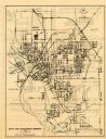
| Description: | Map produced by the Paul E. Stark Company to advertising sales and services. Bottom of the map features sales records for 1919 to 1925 and a paragraph read... |

| Date: | 1925 |
|---|---|
| Description: | Map produced by the Paul E. Stark Company to advertising sales and services. Bottom of the map features sales records for 1919 to 1925 and a paragraph read... |

| Date: | 1927 |
|---|---|
| Description: | Shows campus buildings, points of interest in surrounding area, and railroads. Advertisements on verso. |

| Date: | 1929 |
|---|---|
| Description: | This map is oriented with north to the upper right. Includes index of retailers and buildings, with some advertisements in margins. |
| Date: | 1971 |
|---|---|
| Description: | This map of Stevens Point shows labeled streets and selected points of interest: "Holiday Inn," "Westernberger's Gifts," "Ralph L. Banke MLS Realtor," "Gol... |

| Date: | 1969 |
|---|---|
| Description: | This street map was given out by Mound City Bank and features a legend of points of interest and a street index. Streets are labeled as is the Roundtree Br... |

| Date: | 1960 |
|---|---|
| Description: | This street map was likely given out by Mound City Bank and features a legend of points of interest and a street index. Streets are labeled as is the Round... |
If you didn't find the material you searched for, our Library Reference Staff can help.
Call our reference desk at 608-264-6535 or email us at: