 Filter: Categories of Wisconsin Historical Images
Filter: Subject of Yards
Filter: Subject of landscape
Filter: Categories of Wisconsin Historical Images
Filter: Subject of Yards
Filter: Subject of landscape
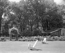
| Date: | 06 16 1963 |
|---|---|
| Description: | Garden, entrance to swimming pool, and pavilion at the Donald Shepard residence, originally the Smith house, built by the son of the founder of the Menasha... |
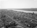
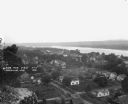
| Date: | 1900 |
|---|---|
| Description: | Aerial view of town. The Mississippi River and far shoreline is in the background. The Furnace Branch creek runs through the town in the foreground. |
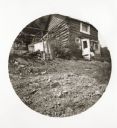
| Date: | 05 12 1894 |
|---|---|
| Description: | A log house built on rocky terrain, opposite Grape Island. |
| Date: | 07 24 1966 |
|---|---|
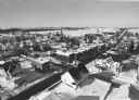
| Description: | Elevated view of small town. A Lake Wisconsin is visible beyond the town limits. |

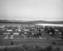
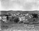
| Date: | 1910 |
|---|---|
| Description: | Elevated view of town and surrounding hills taken from Flat Rock. Caption reads: "Claremont, from Flat Rock." |
| Date: | |
|---|---|
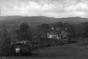
| Description: | View of a large residence surrounded by trees. The mansion sits on a large piece of property with a pond, and a mountainous countryside is in the distance. |
| Date: | 1878 |
|---|---|
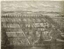
| Description: | Engraved view of a house surrounded by gardens, an evergreen shelter belt and ornamental hedges. |

| Date: | |
|---|---|
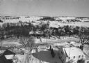
| Description: | View from a hilltop looking down at the village. On the hilltop, there is a small tree. In the village are homes, a church, shops, and in the far distance,... |

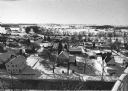
| Date: | 1913 |
|---|---|
| Description: | View of the village during the winter. There are many homes, shops, several churches and open land. Many of the buildings are two stories high. |
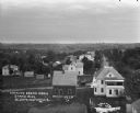
| Date: | 1916 |
|---|---|
| Description: | Elevated view from the water tower. There is a laundry line in the backyard of the white house in the foreground. A car is driving down the road. In the di... |
| Date: | 1913 |
|---|---|
| Description: | View of town. There is a cemetery in the foreground. |

| Date: | |
|---|---|
| Description: | Elevated view of Browntown. In the foreground are farm buildings. |
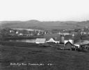
| Date: | 1921 |
|---|---|
| Description: | View from bluff of Cassville with the Mississippi River in the background. |
| Date: | 1913 |
|---|---|
| Description: | Elevated view from hill of the town and hills in the distance. |
| Date: | 1930 |
|---|---|
| Description: | View from hill of a farm near a pond. There are homes along the far shoreline, and a lake and hills in the far background. |
| Date: | 02 02 1978 |
|---|---|
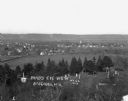
| Description: | "Water tower view, looking due west." |
| Date: | 02 02 1978 |
|---|---|
| Description: | "Groundhog Day... A view from the water tower, looking northwest. The 20mm lens provides a very wide angle of view." |
| Date: | 02 02 1978 |
|---|---|
| Description: | "Water tower view, looking to the east." |
| Date: | 02 02 1978 |
|---|---|
| Description: | "A view from the water tower, looking due south. Groundhog Day was a cloud-free day; forecasting six more weeks of bad weather." |

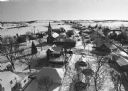
| Date: | 1910 |
|---|---|
| Description: | Elevated view of Mazomanie. The church's steeple stands out in the landscape of houses and barns. |
If you didn't find the material you searched for, our Library Reference Staff can help.
Call our reference desk at 608-264-6535 or email us at: