 Filter: Categories of Wisconsin Historical Images
Filter: Subject of Work
Filter: Subject of water
Filter: Subject of surveyors
Filter: Categories of Wisconsin Historical Images
Filter: Subject of Work
Filter: Subject of water
Filter: Subject of surveyors
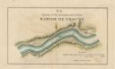
| Date: | 1840 |
|---|---|
| Description: | This map surveyed under the direction of Captain Thomas J. Cram is one in a series of seventeen that accompanied Cram's report on the Fox-Wisconsin river s... |
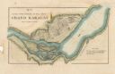
| Date: | 1840 |
|---|---|
| Description: | This map surveyed under the direction of Captain Thomas J. Cram is one in a series of seventeen that accompanied Cram's report on the Fox-Wisconsin river s... |

| Date: | 1840 |
|---|---|
| Description: | This map surveyed under the direction of Captain Thomas J. Cram is one in a series of seventeen that accompanied Cram's report on the Fox-Wisconsin river s... |

| Date: | 1840 |
|---|---|
| Description: | This map surveyed under the direction of Captain Thomas J. Cram is one in a series of seventeen that accompanied Cram's report on the Fox-Wisconsin river s... |

| Date: | 1850 |
|---|---|
| Description: | Ink on paper. Shows local streets and Pekatonika River. "John M. Keep, proprietor. "Original plat of Darlington as surveyed by Richardson on June 14, 1850.... |
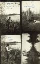
| Date: | |
|---|---|
| Description: | Four scenes of Trout Lake. The top left shows a man surveying on the shoreline of a lake. Handwritten text reads: "PA. MacDonald, Trout Lake 1910." The top... |
If you didn't find the material you searched for, our Library Reference Staff can help.
Call our reference desk at 608-264-6535 or email us at: