 Filter: Categories of Wisconsin Historical Images
Filter: Subject of Work
Filter: Subject of water
Filter: Subject of engineers
Filter: Categories of Wisconsin Historical Images
Filter: Subject of Work
Filter: Subject of water
Filter: Subject of engineers
| Date: | 07 02 1917 |
|---|---|
| Description: | ROTC engineers, probably at Fort Sheridan, learn bridge building during their training at Fort Leavenworth. |

| Date: | 1931 |
|---|---|
| Description: | A topographical map from the U.S. Army Corp of Engineers showing the topography and man-made features in the Camp Williams area of the towns of Orange and ... |
| Date: | 1918 |
|---|---|
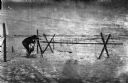
| Description: | Outdoor view of a U.S. Army Engineer topographer wearing skis while in the process of surveying land. The engineer is standing next to a barbed wire obstac... |

| Date: | 1918 |
|---|---|
| Description: | Outdoor view of a U.S. Army Engineer topographer wearing skis while using a tripod stand to write. The engineer is standing next to a barbed wire obstacle ... |

| Date: | 1918 |
|---|---|
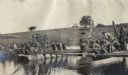
| Description: | Soldiers from the 310th U.S. Army Engineer Corps unloading lumber from barges. |
| Date: | 08 13 1965 |
|---|---|
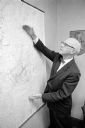
| Description: | H.O. Lord, Madison Metropolitan Sewerage District chief engineer, outlining the existing sewerage district on a map. Lord is trying to educate the public c... |

| Date: | 1965 |
|---|---|
| Description: | This series of 17 maps show boundaries and changes in city limits from 1846 to 1965. The base of all of the maps are the same, Milwaukee and suburbs. All m... |
If you didn't find the material you searched for, our Library Reference Staff can help.
Call our reference desk at 608-264-6535 or email us at: