Filter: Categories of Wisconsin Historical Images
Filter: Subject of Wisconsin State Capitol
Filter: Subject of aerial photographs
Filter: Categories of Wisconsin Historical Images
Filter: Subject of Wisconsin State Capitol
Filter: Subject of aerial photographs

| Date: | 1952 |
|---|---|
| Description: | Aerial view of a North Central Airlines DC-3 airplane flying over the Madison isthmus. Clearly visible are the Wisconsin State Capitol, the 1 West Wilson S... |

| Date: | 1928 |
|---|---|
| Description: | Aerial view of the Wisconsin State Capitol, looking northeast. The Park Hotel on the corner of W. Main Street and S. Carroll Street, is in the foreground. |

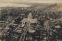
| Date: | 1950 |
|---|---|
| Description: | Aerial view of the Wisconsin State Capitol building and surrounding Madison area. Lake Monona is in the background. |

| Date: | 1958 |
|---|---|
| Description: | Aerial view of the Wisconsin State Capitol and surrounding area. The view is looking northwest, with King Street on the bottom right, and S. Hamilton Stree... |

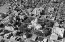
| Date: | 1908 |
|---|---|
| Description: | A panoramic aerial view of the Isthmus taken from a kite. Lake Mendota is to the right in the background with Picnic Point jutting into the lake. The photo... |

| Date: | 05 09 1908 |
|---|---|
| Description: | Kite aerial panoramic photograph of the central business district. In the distance is Lake Mendota. The fire damaged Wisconsin State Capitol is in the cent... |

| Date: | 08 20 1930 |
|---|---|
| Description: | Aerial view of the Madison skyline from University of Wisconsin Field House, overlooking the Wisconsin State Capitol and, in the foreground, Gateway Lumber... |

| Date: | 1922 |
|---|---|
| Description: | Aerial view of the Wisconsin State Capitol and Lake Monona. |
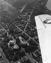
| Date: | 1954 |
|---|---|
| Description: | Aerial view of the Wisconsin State Capitol, including a bit of the airplane wing. |

| Date: | 1928 |
|---|---|
| Description: | Aerial view of Madison looking southeast over the isthmus, showing the Four Lakes Country. Visible at the bottom is the Lake Mendota shoreline. At center, ... |

| Date: | 1948 |
|---|---|
| Description: | Aerial view of the Wisconsin State Capitol and surrounding area looking south southeast towards Lake Monona. |

| Date: | 1955 |
|---|---|
| Description: | An air view of Madison's downtown area with the Wisconsin State Capitol and new State Office Buildings. |

| Date: | 1919 |
|---|---|
| Description: | Aerial view from King Street looking southwest to the University of Wisconsin campus. |

| Date: | 1919 |
|---|---|
| Description: | Aerial view with the Wisconsin State Capitol in the foreground, and the tip of Monona Bay and Lake Wingra to the left, with horizon stretching into the dis... |

| Date: | 1930 |
|---|---|
| Description: | Aerial view of isthmus looking east toward Lake Mendota and the Wisconsin State Capitol, with Lake Monona and the horizon in the background. |
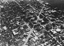
| Date: | 1928 |
|---|---|
| Description: | Aerial view of Capitol Square and vicinity, looking east-northeast. State Street is visible at the bottom center. |
| Date: | 1919 |
|---|---|
| Description: | Aerial view of the Capitol Square and surrounding area. Lake Monona and Lake Wingra are in the background. |

| Date: | |
|---|---|
| Description: | Aerial view over the Wisconsin State Capitol looking south south-east. |
If you didn't find the material you searched for, our Library Reference Staff can help.
Call our reference desk at 608-264-6535 or email us at: