Filter: Categories of Wisconsin Historical Images
Filter: Subject of Wisconsin River (Wis.)
Filter: Categories of Wisconsin Historical Images
Filter: Subject of Wisconsin River (Wis.)

| Date: | 1955 |
|---|---|
| Description: | Aerial view of Castle Rock Dam on the Wisconsin River. |

| Date: | 10 1905 |
|---|---|
| Description: | Elevated view from Reservoir Bluff to the east of the town. The bluffs of Iowa can be seen in the distance. |

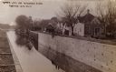
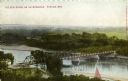
| Date: | 1920 |
|---|---|
| Description: | Elevated view of old toll bridge across the Wisconsin River at Prairie du Sac. The view is looking north toward Sauk County. |

| Date: | |
|---|---|
| Description: | Construction of the new Wisconsin River Bridge at Prairie du Sac taken by Melvin Diemer for the Wisconsin Goods Roads Association. The old toll bridge is v... |
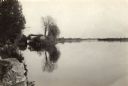
| Date: | 1935 |
|---|---|
| Description: | The Wisconsin River looking downstream. The Wisconsin River end of the canal may be seen at the left. |
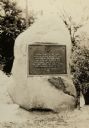
| Date: | 1928 |
|---|---|
| Description: | The Pierre Pauquette monument, located on the bank of the Wisconsin River where he operated a ferry between the years 1828 and 1836. Erected by the Wau-bun... |
| Date: | 1910 |
|---|---|
| Description: | The Portage Canal at the Wisconsin River, showing the upper lock. Caption reads: "Upper Lock and Wisconsin River Portage Wis. No. 10". A group of people ar... |

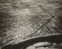
| Date: | 1945 |
|---|---|
| Description: | An aerial view of the Portage Canal, Fox and Wisconsin Rivers. |
| Date: | 1900 |
|---|---|
| Description: | Elevated view of a bridge over the Wisconsin River. Caption reads: "The New Bridge on the Wisconsin, Portage, Wis." |
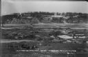
| Date: | 1945 |
|---|---|
| Description: | An elevated view of Portage and it's vicinity. |

| Date: | 1829 |
|---|---|
| Description: | Photoprint of Crawford County lead district map. |

| Date: | 1950 |
|---|---|
| Description: | Aerial view of the Highway 21 bridge and Petenwell Dam on the Wisconsin River. |

| Date: | 08 03 1946 |
|---|---|
| Description: | View of the Wisconsin River from Cactus Bluff. |
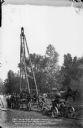
| Date: | 08 11 1910 |
|---|---|
| Description: | The first machinery at work sounding at the site for the power dam. Workmen are posing near the carriage-mounted equipment. A horse-drawn wagon is in the ... |
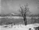
| Date: | 1911 |
|---|---|
| Description: | Frozen Wisconsin River from the east bank looking west, marked to show the future location of the power dam. Logs and stumps indicate prior clearing of th... |
| Date: | 1911 |
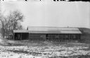
|---|---|
| Description: | Newly constructed office building at construction site, with buggy in attached shed. |

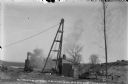
| Date: | 1911 |
|---|---|
| Description: | Workers erecting a steam driven pile driver while others survey for the railroad extension from the village of Prairie du Sac to the dam site on the Wiscon... |
| Date: | 1911 |
|---|---|
| Description: | Steam-powered pile driver and centrifugal pump (in shed) at work at the Wisconsin River dam site. Men and children are watching the work. |
If you didn't find the material you searched for, our Library Reference Staff can help.
Call our reference desk at 608-264-6535 or email us at: