 Filter: Categories of Wisconsin Historical Images
Filter: Subject of Wisconsin River (Wis.)
Filter: Year of 1900-1999
Filter: Year of 1960-1969
Filter: Categories of Wisconsin Historical Images
Filter: Subject of Wisconsin River (Wis.)
Filter: Year of 1900-1999
Filter: Year of 1960-1969
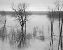
| Date: | 04 18 1965 |
|---|---|
| Description: | Wisconsin River in flood, looking downstream. |
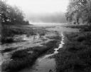
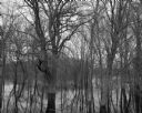
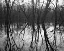
| Date: | 08 13 1961 |
|---|---|
| Description: | A Wisconsin River swamp. The swampy area is framed by trees with more trees in the background hidden by fog. |
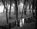
| Date: | 09 22 1962 |
|---|---|
| Description: | Elevated view of trees and pool of water near the Wisconsin River in Pauquette Park. |
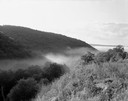
| Date: | 07 04 1965 |
|---|---|
| Description: | Hills and fog at sunrise, looking out from the north side of the Wisconsin River. |

| Date: | 05 02 1964 |
|---|---|
| Description: | Sitting on the school lawn, students draw Highway 51, Marathon Mill, Rib mountain and the Wisconsin River. |

| Date: | 1965 |
|---|---|
| Description: | Aerial view that encompasses most of the town and part of the Wisconsin River. |
| Date: | 04 18 1965 |
|---|---|
| Description: | View of a wooded area affected by a Wisconsin River flood. |
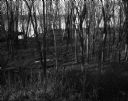
| Date: | 11 11 1961 |
|---|---|
| Description: | View along the Wisconsin River, looking upstream from near Tower Hill State Park toward Highway 14 bridge. |
| Date: | 11 11 1961 |
|---|---|
| Description: | View through patch of dense tree growth towards a Wisconsin River riverbank. |

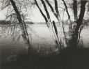
| Date: | 08 20 1961 |
|---|---|
| Description: | A tree-lined view of the Wisconsin River. The photograph was taken from an elevated area near a highway. |
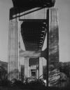
| Date: | 08 19 1961 |
|---|---|
| Description: | View straight through support structure of underside of a bridge that crosses the Wisconsin River. The far shoreline of trees and hills can be seen in the ... |
| Date: | 04 17 1965 |
|---|---|
| Description: | Flooded woods near the Wisconsin River. A sign for "The Dutch Kitchen" at Hotel Meyers is nailed to one of the trees. |
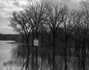
| Date: | 04 18 1965 |
|---|---|
| Description: | View of a grove of trees and their reflections in the flooded Wisconsin River bottomlands. |
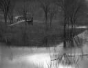
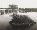
| Date: | 04 18 1965 |
|---|---|
| Description: | A flooded woods near the Wisconsin River. A small bridge and a submerged road are in the background. |
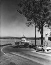
| Date: | 1963 |
|---|---|
| Description: | View from road of the ferry "Colsac II" arriving at the shoreline of the Wisconsin River, with an automobile on the right waiting to board. |

| Date: | 1961 |
|---|---|
| Description: | View from shoreline of a woman standing on a riverbank waving at the Merrimac ferry. |

| Date: | 1961 |
|---|---|
| Description: | The Merrimac Ferry is on the river with a pick-up truck aboard. A rowboat rests on a pier in the foreground. A man wearing a hat rests his foot on the rail... |

| Date: | 1965 |
|---|---|
| Description: | Map shows original plat, plat additions, and lot measurements for Rothschild, Wisconsin. Lake Wausau and the Wisconsin River are labelled. Map reads: "Comp... |
| Date: | 1963 |
|---|---|
| Description: | Cement and steel bridge over the Wisconsin River. Alongside are the ruined stone foundations of the former bridge. |

| Date: | 07 04 1965 |
|---|---|
| Description: | Text on back of Pairing, "Sunrise on treetops along the north shore of the Wisconsin River, near Boscobel, but in Crawford County." Fog fills the middle gr... |
If you didn't find the material you searched for, our Library Reference Staff can help.
Call our reference desk at 608-264-6535 or email us at: