Filter: Categories of Wisconsin Historical Images
Filter: Subject of Wisconsin River (Wis.)
Filter: Year of 1900-1999
Filter: Year of 1940-1949
Filter: Categories of Wisconsin Historical Images
Filter: Subject of Wisconsin River (Wis.)
Filter: Year of 1900-1999
Filter: Year of 1940-1949

| Date: | 1945 |
|---|---|
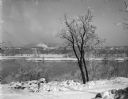
| Description: | Wyalusing State Park in the Prairie du Chein vicinity. The Wisconsin River is in the foreground and the Mississippi river can be seen below with distant bl... |
| Date: | 1940 |
|---|---|
| Description: | Aerial view of the Wisconsin Power and Light Company generating plant and dam. |
| Date: | 1945 |
|---|---|
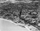
| Description: | View of the Wausau Memorial Hospital, with the Wisconsin River in the foreground. |
| Date: | 1945 |
|---|---|
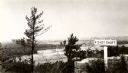
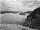
| Description: | View from the bluff at Tower Hill State Park of the Wisconsin River. A sign on the right reads: "Tower Hill State Park Shot Shaft". |

| Date: | 1945 |
|---|---|
| Description: | Aerial view of Taliesin, Frank Lloyd Wright's residence and architectural school complex, with the Wisconsin River visible at the top. Taliesin is located... |

| Date: | 1945 |
|---|---|
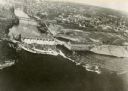
| Description: | An aerial view of the Portage Canal, Fox and Wisconsin Rivers. |
| Date: | 1945 |
|---|---|
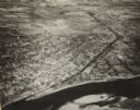
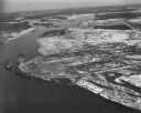
| Description: | An elevated view of Portage and it's vicinity. |
| Date: | 08 03 1946 |
|---|---|
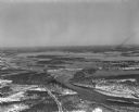
| Description: | View of the Wisconsin River from Cactus Bluff. |
| Date: | 02 09 1949 |
|---|---|
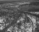
| Description: | One of five aerial views of Portage, including the frozen Wisconsin River. |
| Date: | 04 16 1949 |
|---|---|
| Description: | Aerial view of Necedah, Wisconsin, and Petenwell Lake behind Petenwell Dam on the Wisconsin River. |
| Date: | 04 16 1949 |
|---|---|
| Description: | Aerial view of Castle Rock Dam on the Wisconsin River near Mauston, Wisconsin. |
| Date: | 04 16 1949 |
|---|---|
| Description: | Aerial view of Petenwell Dam and dike on Wisconsin River twenty miles north of Necedah, Wisconsin showing the early formation of Lake Petenwell. |

| Date: | 1942 |
|---|---|
| Description: | This map shows the Wisconsin and Fox River routes in green, and the Milwaukee and Rock River Canal routes in red. Prairie du Chien, Fort Winnebago, Grand C... |

| Date: | 1948 |
|---|---|
| Description: | This outline map of Sauk County, Wisconsin, shows the towns, cities and villages, railroads, and streams in the county. |

| Date: | 1940 |
|---|---|
| Description: | This map of the Wisconsin Dells shows original plats and various additions. Some streets are labeled as is the Wisconsin River. The map was originally crea... |

| Date: | 08 1940 |
|---|---|
| Description: | View looking down towards a woman wearing a striped dress and holding a purse standing at a low stone wall at the Point Lookout observation area above the ... |

| Date: | 1944 |
|---|---|
| Description: | Portage County Map. Includes the towns of Eau Plaine, Dewey, Sharon, Alban, Carson, Hull, New Hope, Linwood, Stockton, Amherst, Plover, Grant, Buena Vista,... |

| Date: | 1947 |
|---|---|
| Description: | Text on front reads: "Greetings From Wisconsin Dells, Wisconsin." A Large Letter Postcard with a blue and orange background, each letter is filled with a s... |
| Date: | 1942 |
|---|---|
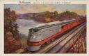
| Description: | Text on front: "The Hiawatha. Crossing the Wisconsin River at the 'Dells'." On reverse: "The Scenic Route. The Milwaukee Road is the only double tracked ro... |
If you didn't find the material you searched for, our Library Reference Staff can help.
Call our reference desk at 608-264-6535 or email us at: