 Filter: Categories of Wisconsin Historical Images
Filter: Subject of Wisconsin River (Wis.)
Filter: Year of 1900-1999
Filter: Year of 1930-1939
Filter: Categories of Wisconsin Historical Images
Filter: Subject of Wisconsin River (Wis.)
Filter: Year of 1900-1999
Filter: Year of 1930-1939

| Date: | 1936 |
|---|---|
| Description: | This map is red and black ink on tracing cloth and is oriented with north to the upper left. This hand-drawn map shows a central portion of the military ro... |
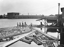
| Date: | 1930 |
|---|---|
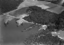
| Description: | Workers push logs floating in the Wisconsin River into alignment to enter a building for processing. |
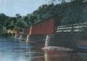
| Date: | 1935 |
|---|---|
| Description: | View of covered bridge above the Wisconsin River, 1 mile from Boscobel. |
| Date: | 1930 |
|---|---|
| Description: | View of covered bridge, built in 1890, over the Wisconsin River with surrounding landscape. |
| Date: | 1933 |
|---|---|
| Description: | Elevated view of a covered railroad bridge over a calm body of water, with bluffs in the background. |
| Date: | 1930 |
|---|---|
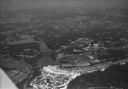
| Description: | Aerial view of the town of Wisconsin Dells, the dam on the Wisconsin River, and the generating plant. The town of Wisconsin Dells was known as Kilbourn Cit... |

| Date: | 1930 |
|---|---|
| Description: | Aerial view of Wisconsin Dells including the Wisconsin River and the dam and generating power plant. |
| Date: | 1930 |
|---|---|
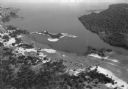
| Description: | Aerial view of Lake Delton, the Wisconsin River, and the surrounding countryside. |
| Date: | 1930 |
|---|---|
| Description: | Aerial view of Lake Delton and shoreline including resort areas. |
| Date: | 1930 |
|---|---|
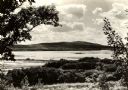
| Description: | View looking west at Rib Mountain across the Wisconsin River from the outskirts of Wausau. |

| Date: | 1930 |
|---|---|
| Description: | A view looking west at Rib Mountain across the Wisconsin River from the outskirts of Wausau. |
| Date: | 1935 |
|---|---|
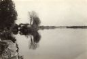
| Description: | The Wisconsin River looking downstream. The Wisconsin River end of the canal may be seen at the left. |
| Date: | 1930 |
|---|---|
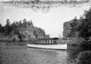
| Description: | The skipper guides the motor launch Miss Helen on the Wisconsin River in the Dells. |

| Date: | 1936 |
|---|---|
| Description: | A view of the Dells of the Wisconsin River, with two people walking down a long dock/walkway leading to a boat. |
| Date: | 01 23 1931 |
|---|---|
| Description: | View from shoreline of bridge during construction over the icy river. |
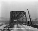
| Date: | 1931 |
|---|---|
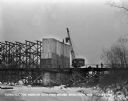
| Description: | View from shoreline of a crane lifting machinery to workers at the top of the bridge during construction. Words on the crane reads, "Stevens Brothers and S... |
| Date: | 1931 |
|---|---|
| Description: | The entrance to the bridge during construction. A worker works on the side of the bridge on the right. Other workers in the middle of the bridge lay boards... |
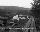
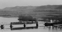
| Date: | 08 29 1930 |
|---|---|
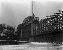
| Description: | View from top of new bridge of construction grounds at the bridge site. There are cars carrying building materials on the railroad tracks by the Bridgeport... |

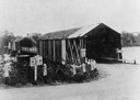
| Date: | 08 29 1930 |
|---|---|
| Description: | Workers pose at the entrance of the old bridge. There are railroad tracks in the foreground with signs that read, "free bridge," "men working," and "cautio... |

| Date: | 1935 |
|---|---|
| Description: | This map shows Wisconsin’s pinery region. Lake Superior, Lake Michigan, Lake Winnebago, Green Bay, the Wisconsin River, and the Mississippi River are label... |
If you didn't find the material you searched for, our Library Reference Staff can help.
Call our reference desk at 608-264-6535 or email us at: