Filter: Categories of Wisconsin Historical Images
Filter: Subject of Wisconsin River (Wis.)
Filter: Year of 1900-1999
Filter: Categories of Wisconsin Historical Images
Filter: Subject of Wisconsin River (Wis.)
Filter: Year of 1900-1999
| Date: | 11 01 1913 |
|---|---|
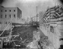
| Description: | Wooden forms are in place for construction of the walls of the lock at the Prairie du Sac dam. The newly constructed power house is on the left. |
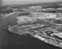
| Date: | 1924 |
|---|---|
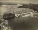
| Description: | Aerial view of the Prairie du Sac hydroelectric plant and the surrounding landscape of the Wisconsin River. |
| Date: | 1910 |
|---|---|
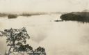
| Description: | Elevated view of high water on the Wisconsin River from a bluff on the west bank. The photograph is undated and does not indicate if it was taken prior to ... |
| Date: | 1907 |
|---|---|
| Description: | A view of the west bank of the Wisconsin River at Pounds Landing. This bluff is at the western end of the power dam which was constructed 1911-1914. Captio... |
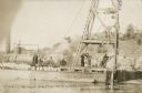
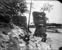
| Date: | 05 28 1911 |
|---|---|
| Description: | Men posing on a barge carrying a steam powered pile driver at work on the coffer dam for the construction of the powerhouse. Caption reads: "Driving Sheet ... |

| Date: | 1907 |
|---|---|
| Description: | Topographic map of the Wisconsin River done under direction of Daniel Meade for construction of the Kilbourn dam by the Southern Wisconsin Power Company. I... |
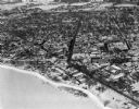
| Date: | 02 09 1949 |
|---|---|
| Description: | One of five aerial views of Portage, including the frozen Wisconsin River. |
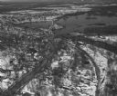
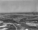
| Date: | 04 16 1949 |
|---|---|
| Description: | Aerial view of Necedah, Wisconsin, and Petenwell Lake behind Petenwell Dam on the Wisconsin River. |
| Date: | 04 16 1949 |
|---|---|
| Description: | Aerial view of Castle Rock Dam on the Wisconsin River near Mauston, Wisconsin. |
| Date: | 04 16 1949 |
|---|---|
| Description: | Aerial view of Petenwell Dam and dike on Wisconsin River twenty miles north of Necedah, Wisconsin showing the early formation of Lake Petenwell. |

| Date: | 1903 |
|---|---|
| Description: | Group of people on the excursion steamer Eleanor in the Dells. |
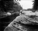
| Date: | 1903 |
|---|---|
| Description: | The photographer's son, Cary Bass, and a dog on a rock formation in the Wisconsin Dells near the Wisconsin River. In the background there is writing on a r... |
| Date: | 1910 |
|---|---|
| Description: | A winter view of Chimney Rock at the Dells. There is snow on the ground and ice on the river. |
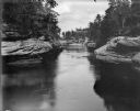
| Date: | 1910 |
|---|---|
| Description: | View from bank of the Wisconsin River of the Jaws of the Dells in winter. Snow is on the ground and ice lines the shoreline. |
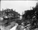
| Date: | 1910 |
|---|---|
| Description: | The Locks and Jaws of the Dells in winter, taken at Devil's Elbow. The roof of the Larks Hotel, with the hotel's name on it, is visible in the background. |
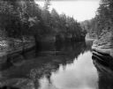
| Date: | 1910 |
|---|---|
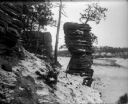
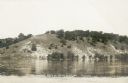
| Description: | A view of the rock formations along the Wisconsin River at the Dells. |
| Date: | 1910 |
|---|---|
| Description: | View across Wisconsin River of men and women in canoes at the base of Lone Rock at the Dells. |
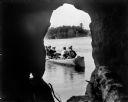
| Date: | 1910 |
|---|---|
| Description: | A man paddles a canoe with four women passengers, as seen from inside Lone Rock Cave at the Dells. The far shoreline can be seen in the background. |
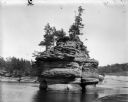
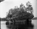
| Date: | 1910 |
|---|---|
| Description: | The rock formation at the Dells known as the Sugar Bowl. |
If you didn't find the material you searched for, our Library Reference Staff can help.
Call our reference desk at 608-264-6535 or email us at: