Filter: Categories of Wisconsin Historical Images
Filter: Subject of Wisconsin River (Wis.)
Filter: Year of 1900-1999
Filter: Community of Wausau
Filter: Categories of Wisconsin Historical Images
Filter: Subject of Wisconsin River (Wis.)
Filter: Year of 1900-1999
Filter: Community of Wausau
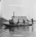
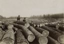
| Date: | 1913 |
|---|---|
| Description: | Eight men are in a boat driving logs down the Wisconsin River. |
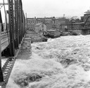
| Date: | 1916 |
|---|---|
| Description: | Water churns under a railroad bridge as the spring thaw swells the Wisconsin River. |
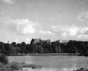
| Date: | 1945 |
|---|---|
| Description: | View of the Wausau Memorial Hospital, with the Wisconsin River in the foreground. |
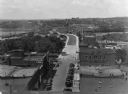
| Date: | 1928 |
|---|---|
| Description: | Elevated view of the main street with the Wisconsin River in the top left corner. The street just outside the Hall Garage Company is lined with cars. |
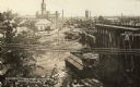
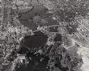
| Date: | 07 1912 |
|---|---|
| Description: | Elevated view across the Wisconsin River, showing the wreckage left by the disastrous flood of July 24, 1912. A power dam on the Wisconsin River above Waus... |
| Date: | 1909 |
|---|---|
| Description: | View from shoreline towards Stroller's Bridge. Caption reads: "Strollers Bridge and the Old Wisconse, Wausau, Wis." |
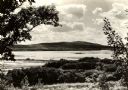
| Date: | 1930 |
|---|---|
| Description: | View looking west at Rib Mountain across the Wisconsin River from the outskirts of Wausau. |

| Date: | 1905 |
|---|---|
| Description: | View across water toward East Hill. Caption reads: "East Hill, from Depot Grounds, Wausau, Wis." |
| Date: | 1925 |
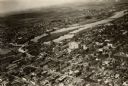
|---|---|
| Description: | Aerial view of buildings in the downtown area. |
| Date: | 1918 |
|---|---|
| Description: | View of the bridge over the Wisconsin River at Big Bull Falls, seen at low water. |

| Date: | 1900 |
|---|---|
| Description: | View from bank of river towards the Cereal Mills Company, looking North toward Big Bull Falls. |
| Date: | 1900 |
|---|---|
| Description: | Two women and one man in street clothes and wearing hats posing among the logs of a large log jam on the Wisconsin River. |

| Date: | 1978 |
|---|---|
| Description: | Students at Wausau West High School involved in an innovative science project that studied energy consumption and pollution of the Wisconsin River. |

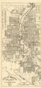
| Date: | 1932 |
|---|---|
| Description: | This map of Wausau shows lots and landownership, buildings, roads, railroads, parks, city wards, and the Wisconsin River. The map features an inset map sho... |
| Date: | 1955 |
|---|---|
| Description: | This map of Wausau distributed by the Wausau Chamber of Commerce was originally published in July of 1940 and shows the Wisconsin River. The map includes a... |
| Date: | 1928 |
|---|---|
| Description: | This plat map of Wausau is oriented with north to the right and is dated "April, 1928." The map features a building description chart with an index and inc... |

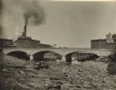
| Date: | 1916 |
|---|---|
| Description: | Water of Big Bull Falls or the Wisconsin River rapidly flows underneath two railroad bridges. Pedestrians cross the bridges while peering over at the over... |
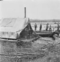
| Date: | 1912 |
|---|---|
| Description: | Businessmen visiting a log drive down the Wisconsin River. One man wearing a vest sits in a boat holding a peavey hook over his shoulder. Other men wearing... |
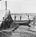
| Date: | 1912 |
|---|---|
| Description: | View from shoreline over tree branches of three businessmen visiting a logging crew on the Wisconsin River. One businessman sits on a boat while two others... |
If you didn't find the material you searched for, our Library Reference Staff can help.
Call our reference desk at 608-264-6535 or email us at: