Filter: Categories of Wisconsin Historical Images
Filter: Subject of Wisconsin River (Wis.)
Filter: Year of 1800-1899
Filter: Year of 1830-1839
Filter: Categories of Wisconsin Historical Images
Filter: Subject of Wisconsin River (Wis.)
Filter: Year of 1800-1899
Filter: Year of 1830-1839
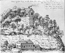
| Date: | 1836 |
|---|---|
| Description: | The shot tower at Tower Hill State Park. |

| Date: | 1835 |
|---|---|
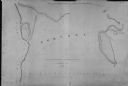
| Description: | Ink on tracing paper map of Green Bay, Wisconsin and nearby areas, Lake Winnebago, Fox and Wolf Rivers, and the junctions of the Mississippi and Wisconsin ... |

| Date: | 1835 |
|---|---|
| Description: | Plat for a proposed Sinsinawa City (never built), in Grant County, Wis. When it became clear in the mid-1830s that Wisconsin Territory would be established... |

| Date: | 1832 |
|---|---|
| Description: | This map shows lot and block numbers, as well as the location of a shot tower, houses, stores, and barns. The map is oriented with the north to the left. T... |
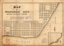
| Date: | 1836 |
|---|---|
| Description: | This map shows proposed lot and block numbers for a paper city located in township 10 north, range 7 east, Wisconsin Territory, now the Town of West Point,... |

| Date: | 1838 |
|---|---|
| Description: | This map is a development plat that shows street names, numbered blocks and lots, and small farm lot owners. Included on the right of the map is a large am... |

| Date: | 11 1836 |
|---|---|
| Description: | This map is pen-and-ink on paper and is a plat of a paper city on the Wisconsin River, in what is now the Town of Dekorra. The map shows lot and block numb... |

| Date: | 1836 |
|---|---|
| Description: | This map shows lot and block numbers, streets, a proposed canal basin, Fort Winnebago, and the Wisconsin and Fox Rivers. Relief is shown by hachures and no... |

| Date: | 1839 |
|---|---|
| Description: | This map, one of a series made by Thomas Jefferson Cram of the U.S. Topographical Engineers from personal surveys, covers the area from Green Bay to the ju... |

| Date: | 1837 |
|---|---|
| Description: | This map shows the planned military posts/depots, roads, existing forts, rivers, and land assigned to various Indian tribes. Illinois, Mississippi, Arkansa... |

| Date: | 1837 |
|---|---|
| Description: | This map shows planned military posts/depots, barracks, rivers, lakes, roads, existing forts, and land assigned to various Indian tribes. Arkansas, Illinoi... |
| Date: | 1839 |
|---|---|
| Description: | This map oriented with north to the upper right shows portage between the Wisconsin and Fox Rivers, as well as line of proposed construction for defense ag... |
If you didn't find the material you searched for, our Library Reference Staff can help.
Call our reference desk at 608-264-6535 or email us at: