Filter: Categories of Wisconsin Historical Images
Filter: Subject of Wisconsin River (Wis.)
Filter: Year of 1800-1899
Filter: Subject of transportation
Filter: Year of 1890-1899
Filter: Categories of Wisconsin Historical Images
Filter: Subject of Wisconsin River (Wis.)
Filter: Year of 1800-1899
Filter: Subject of transportation
Filter: Year of 1890-1899

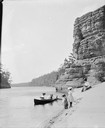
| Date: | 1897 |
|---|---|
| Description: | A view of Lone Rock from below, with a canoe on the left-hand side. |

| Date: | 1891 |
|---|---|
| Description: | Bird's-eye map of Wausau, looking north with ninety-eight businesses, industries, churches, schools, and civic buildings identified in location key below i... |
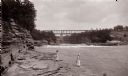
| Date: | 1890 |
|---|---|
| Description: | Below Kilbourn log dam, 1890s. Two girls are standing on the edge of the river. There is a bridge in the background. |
| Date: | 07 16 1899 |
|---|---|
| Description: | View along sandy shoreline towards the Bennett family on the beach at High Rock. Ashley and Helen are in the boat, and Miriam and Ruth are standing on the ... |
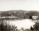
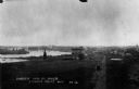
| Date: | 1890 |
|---|---|
| Description: | Elevated view looking up the Wisconsin River, with Wausau in the background. There are railroad cars on a bridge on the right. |
| Date: | 1898 |
|---|---|
| Description: | Elevated view of the Jackson Milling Company, the Green Bay railroad tracks, and the Wisconsin Central railroad tracks. Caption reads: "Birdseye View of Ri... |

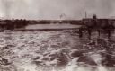
| Date: | 1894 |
|---|---|
| Description: | Panoramic view from shoreline of the Wisconsin River in the Wisconsin Dells as seen from the "Old Dell House." A canoe is visible on the shore on the far r... |

| Date: | 1896 |
|---|---|
| Description: | Section 5 of 12, this bicycle road map features Wisconsin bicycle routes in the counties of La Crosse, Monroe, Vernon, Crawford, Richland, Sauk, Juneau, an... |

| Date: | 1896 |
|---|---|
| Description: | A map showing the Wisconsin Central Railroad lines in Wisconsin, northern Illinois, eastern Minnesota, and Michigan’s Upper Peninsula. The area of the map ... |

| Date: | 1890 |
|---|---|
| Description: | Group of tourists and crew members on the bow deck of the DELL QUEEN, an excursion boat that operated on the Wisconsin River at Wisconsin Dells. |
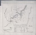
| Date: | 1897 |
|---|---|
| Description: | This map shows the distances along Fox River, as well as adjacent lakes and railroads, between Green Bay and the Wisconsin River. Lake Michigan is on the f... |

| Date: | 1892 |
|---|---|
| Description: | A Sanborn fire insurance map of Sauk City which was drawn up in 1892. |

| Date: | 1891 |
|---|---|
| Description: | The index page of a Sanborn Map of Stevens Point. |
If you didn't find the material you searched for, our Library Reference Staff can help.
Call our reference desk at 608-264-6535 or email us at: