 Filter: Categories of Wisconsin Historical Images
Filter: Subject of Wisconsin River (Wis.)
Filter: County of Sauk
Filter: Categories of Wisconsin Historical Images
Filter: Subject of Wisconsin River (Wis.)
Filter: County of Sauk
| Date: | |
|---|---|
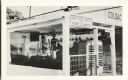
| Description: | A close view of the Merrimac ferry "Colsac I" with a sign reading, "Stop Your Motor When Ferry Is Moving". |
| Date: | |
|---|---|
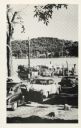
| Description: | Automobiles line up to wait for the Merrimac ferry "Colsac". |
| Date: | |
|---|---|
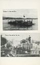
| Description: | Two images of ferries as printed on a postcard. The top image is the ferry "Colsac" on the Wisconsin River. The bottom image is simply described as an earl... |

| Date: | 1910 |
|---|---|
| Description: | A man and boy wearing hats and overalls stand on a ferry docked at the shoreline. On the ferry is a car. The far shoreline and low hills are in the backgro... |
| Date: | 1869 |
|---|---|
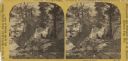
| Description: | Two girls in long dresses on a rock formation. The river and far shoreline is in the background. Text on left reads: "A Visit to Devil's Lake, Sauk County,... |

| Date: | 1912 |
|---|---|
| Description: | This outline map of Sauk County, Wisconsin, shows the towns, cities and villages, railroads, and streams in the county. |

| Date: | 1877 |
|---|---|
| Description: | This 1877 map of Sauk County, Wisconsin, shows the township and range grid, sections, towns, cities and villages, land ownership and acreages, wagon roads,... |

| Date: | 1939 |
|---|---|
| Description: | This map of Sauk County, Wisconsin, shows the township and range grid, towns, sections, cities and villages, roads, railroads, lakes and rivers, schools, a... |
| Date: | 1975 |
|---|---|
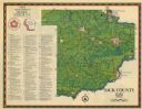
| Description: | This 1975 map of Sauk County, Wisconsin, lists and locates historic sites and other points of interest in the county. |

| Date: | 1990 |
|---|---|
| Description: | This late 20th century tourist map of Sauk County, Wisconsin, shows the highways and roads, cities and towns, parks, airports, canoe landings, hospitals, s... |

| Date: | 1948 |
|---|---|
| Description: | This outline map of Sauk County, Wisconsin, shows the towns, cities and villages, railroads, and streams in the county. |

| Date: | 1866 |
|---|---|
| Description: | This manuscript map by Increase Lapham shows the Dells of the Wisconsin River, from Stand Rock and Witches Gulch at the north to a point approximately one ... |

| Date: | 1915 |
|---|---|
| Description: | This 1915 map covers the section of the Wisconsin River in southern Adams, southeastern Juneau, northeastern Sauk, and northwestern Columbia counties. A po... |

| Date: | 1859 |
|---|---|
| Description: | Shows townships and sections, landownership, roads, railroads, rural residences, schools, churches, and topography. Relief shown by hachures. "From governm... |
| Date: | 1922 |
|---|---|
| Description: | View from shoreline of bridge over the Wisconsin River. In the left lower foreground is a shed, and a rowboat. On the opposite shoreline are farms and fiel... |

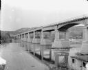
| Date: | 1913 |
|---|---|
| Description: | Elevated view of a power dam on the Wisconsin River under construction. There is a rowboat in the foreground. On the opposite shoreline are trees and bluff... |

| Date: | |
|---|---|
| Description: | View across water towards a wooden wagon bridge over the Wisconsin River. A farm and tree-covered hills are on the opposite shoreline. |
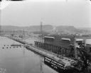
| Date: | 1922 |
|---|---|
| Description: | Elevated view of the power plant and dam on the Wisconsin River. Two workers are walking near the center. On the opposite shoreline are fields and tree-cov... |

| Date: | 1909 |
|---|---|
| Description: | A view from shoreline below a bridge that crosses the Wisconsin River. There are two signs on the upper level of the bridge. One is for weight limit and th... |

| Date: | 1905 |
|---|---|
| Description: | Picnicking group of men and women along the shore of the Wisconsin River. |
If you didn't find the material you searched for, our Library Reference Staff can help.
Call our reference desk at 608-264-6535 or email us at: