Filter: Categories of Wisconsin Historical Images
Filter: Subject of Wisconsin River (Wis.)
Filter: County of Marathon
Filter: Categories of Wisconsin Historical Images
Filter: Subject of Wisconsin River (Wis.)
Filter: County of Marathon
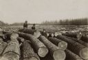
| Date: | 1900 |
|---|---|
| Description: | Two women and one man in street clothes and wearing hats posing among the logs of a large log jam on the Wisconsin River. |

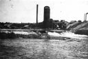
| Date: | |
|---|---|
| Description: | View up the Wisconsin River showing the dam and a bridge. A streetcar and a small group of people are gathered on one end. |
| Date: | 1978 |
|---|---|
| Description: | Students at Wausau West High School involved in an innovative science project that studied energy consumption and pollution of the Wisconsin River. |

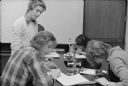
| Date: | 1965 |
|---|---|
| Description: | Map shows original plat, plat additions, and lot measurements for Rothschild, Wisconsin. Lake Wausau and the Wisconsin River are labelled. Map reads: "Comp... |

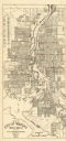
| Date: | 1932 |
|---|---|
| Description: | This map of Wausau shows lots and landownership, buildings, roads, railroads, parks, city wards, and the Wisconsin River. The map features an inset map sho... |
| Date: | 1955 |
|---|---|
| Description: | This map of Wausau distributed by the Wausau Chamber of Commerce was originally published in July of 1940 and shows the Wisconsin River. The map includes a... |
| Date: | 1928 |
|---|---|
| Description: | This plat map of Wausau is oriented with north to the right and is dated "April, 1928." The map features a building description chart with an index and inc... |

| Date: | 1916 |
|---|---|
| Description: | Water of Big Bull Falls or the Wisconsin River rapidly flows underneath two railroad bridges. Pedestrians cross the bridges while peering over at the over... |
| Date: | 1912 |
|---|---|
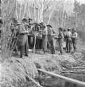
| Description: | Businessmen visiting a log drive down the Wisconsin River. One man wearing a vest sits in a boat holding a peavey hook over his shoulder. Other men wearing... |
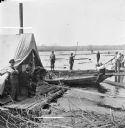
| Date: | 1912 |
|---|---|
| Description: | View from shoreline over tree branches of three businessmen visiting a logging crew on the Wisconsin River. One businessman sits on a boat while two others... |
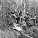
| Date: | 1912 |
|---|---|
| Description: | View towards shoreline of log drivers eating lunch on the edge of the riverbank. Visiting businessmen share a meal with the log drivers who are sitting and... |
| Date: | 1912 |
|---|---|
| Description: | View towards shoreline of log drivers eating lunch on the edge of the riverbank. The men wait in line along a buffet table filled with provisions. The busi... |
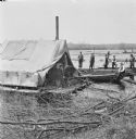
| Date: | 1912 |
|---|---|
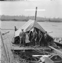
| Description: | View looking down from riverbank of four businessmen and the log driving cook posing on the cooks tent barge during the log drive. |
| Date: | 1912 |
|---|---|
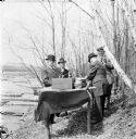
| Description: | Four businessmen standing around a table, eating along the banks of the Wisconsin River. The table is set with a stack of bowls and a crate of apples. Logs... |

| Date: | 1982 |
|---|---|
| Description: | Color map. "Topography by photogrammetric methods from aerial photographs taken 1963. Revised from aerial photographs taken 1978. Field checked 1979. Map e... |

| Date: | 1915 |
|---|---|
| Description: | This map is mounted on cloth and shows lots and landownership, selected buildings, roads, railroads, parks, cemeteries, city wards, and includes advertisem... |

| Date: | 1987 |
|---|---|
| Description: | This pictorial map shows roads, bridges, local businesses with phone numbers, and public buildings. Relief is shown pictorially. Also included is a calen... |

| Date: | 1901 |
|---|---|
| Description: | A plat map of Marathon county, 28 township, north range, 7 east. |

| Date: | 1901 |
|---|---|
| Description: | A plat map of Marathon county, township 29, north range, 8 east. |
If you didn't find the material you searched for, our Library Reference Staff can help.
Call our reference desk at 608-264-6535 or email us at: