Filter: Categories of Wisconsin Historical Images
Filter: Subject of Wisconsin River (Wis.)
Filter: County of Marathon
Filter: Categories of Wisconsin Historical Images
Filter: Subject of Wisconsin River (Wis.)
Filter: County of Marathon
| Date: | 1913 |
|---|---|
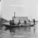
| Description: | Eight men are in a boat driving logs down the Wisconsin River. |

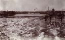
| Date: | 1891 |
|---|---|
| Description: | Bird's-eye map of Wausau, looking north with ninety-eight businesses, industries, churches, schools, and civic buildings identified in location key below i... |
| Date: | 1916 |
|---|---|
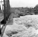
| Description: | Water churns under a railroad bridge as the spring thaw swells the Wisconsin River. |

| Date: | 1879 |
|---|---|
| Description: | This map is a bird's-eye view of Wausau, the County Seat of Marathon County. The map features an index of points of interest. |

| Date: | 05 02 1964 |
|---|---|
| Description: | Sitting on the school lawn, students draw Highway 51, Marathon Mill, Rib mountain and the Wisconsin River. |
| Date: | 1945 |
|---|---|
| Description: | View of the Wausau Memorial Hospital, with the Wisconsin River in the foreground. |
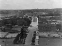
| Date: | 1928 |
|---|---|
| Description: | Elevated view of the main street with the Wisconsin River in the top left corner. The street just outside the Hall Garage Company is lined with cars. |
| Date: | 1890 |
|---|---|
| Description: | Elevated view looking up the Wisconsin River, with Wausau in the background. There are railroad cars on a bridge on the right. |
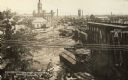
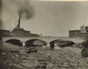
| Date: | 07 1912 |
|---|---|
| Description: | Elevated view across the Wisconsin River, showing the wreckage left by the disastrous flood of July 24, 1912. A power dam on the Wisconsin River above Waus... |
| Date: | 1909 |
|---|---|
| Description: | View from shoreline towards Stroller's Bridge. Caption reads: "Strollers Bridge and the Old Wisconse, Wausau, Wis." |
| Date: | 1930 |
|---|---|
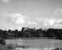
| Description: | View looking west at Rib Mountain across the Wisconsin River from the outskirts of Wausau. |

| Date: | 1905 |
|---|---|
| Description: | View across water toward East Hill. Caption reads: "East Hill, from Depot Grounds, Wausau, Wis." |
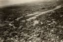
| Date: | 1925 |
|---|---|
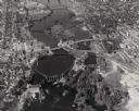
| Description: | Aerial view of buildings in the downtown area. |
| Date: | 1918 |
|---|---|
| Description: | View of the bridge over the Wisconsin River at Big Bull Falls, seen at low water. |

| Date: | 1900 |
|---|---|
| Description: | View from bank of river towards the Cereal Mills Company, looking North toward Big Bull Falls. |
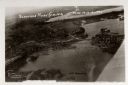
| Date: | 1926 |
|---|---|
| Description: | Aerial view with Wisconsin River. Caption reads: "Schofield Home Coming June 16-17-18-1927". The wing of an airplane is in the right foreground. |

| Date: | 1930 |
|---|---|
| Description: | A view looking west at Rib Mountain across the Wisconsin River from the outskirts of Wausau. |
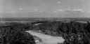
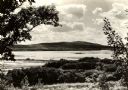
| Date: | 1950 |
|---|---|
| Description: | A view from Rib Mountain looking southeast toward Rothschild and the Wisconsin River. The sign on the road in the foreground reads: "Dangerous Road, Drive ... |
If you didn't find the material you searched for, our Library Reference Staff can help.
Call our reference desk at 608-264-6535 or email us at: