 Filter: Categories of Wisconsin Historical Images
Filter: Subject of Wisconsin River (Wis.)
Filter: County of Lincoln
Filter: Categories of Wisconsin Historical Images
Filter: Subject of Wisconsin River (Wis.)
Filter: County of Lincoln

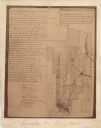
| Date: | 1887 |
|---|---|
| Description: | This map of Tomahawk shows the Wisconsin River, numbered lots, and labeled streets. The back of the map reads: "Henry C. Payne, 424 Broadway, - - Milwaukee... |

| Date: | 1900 |
|---|---|
| Description: | Photographic postcard view up the Wisconsin River near the foot of Grandfather Falls, which falls 90 feet in 1 1/2 miles. Caption reads: "Near the foot of ... |
| Date: | 1900 |
|---|---|
| Description: | This map shows areas of Merrill, Corning, Scott, Rock Falls, Russel, Pelisan, Pine River, Ackley, and the Wisconsin River. The left margin of the map inclu... |
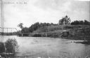
| Date: | 1907 |
|---|---|
| Description: | View across water towards a large Queen Anne style house sitting on a hill above the Wisconsin River. There is a bridge on the left and a road, now South C... |

| Date: | 1901 |
|---|---|
| Description: | A Sanborn map of Tomahawk featuring the Bay Mill Company's lumber yard. |

| Date: | 1935 |
|---|---|
| Description: | View across water towards an unidentified man sitting in the stern of a small boat, holding a fishing rod. A younger man, sitting forward, is rowing. There... |

| Date: | 1907 |
|---|---|
| Description: | Text on front reads: "Train of House Boats, at Tomahawk, Wis." A train of four houseboats in the water with another boat to pull them. Five rowboats are in... |

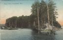
| Date: | 1904 |
|---|---|
| Description: | Text on front reads: "The Hogs Back, Tomahawk, Wis." The Hogs Back is a tree covered peninsula on Lake Mohawksin, also the former name of Bradley Park. A r... |
| Date: | 1907 |
|---|---|
| Description: | Text on front reads: "Hog's Back, Tomahawk, Wis." The Hog's Back is a tree covered peninsula on Lake Mohawksin, also the former name of Bradley Park. A man... |

| Date: | 1955 |
|---|---|
| Description: | Text on front reads: "Greetings from Tomahawk, Wisconsin." A aerial view showing the city and Lake Mohawksin on the Wisconsin River. |
If you didn't find the material you searched for, our Library Reference Staff can help.
Call our reference desk at 608-264-6535 or email us at:
