 Filter: Categories of Wisconsin Historical Images
Filter: Subject of Wisconsin River (Wis.)
Filter: County of Crawford
Filter: Categories of Wisconsin Historical Images
Filter: Subject of Wisconsin River (Wis.)
Filter: County of Crawford
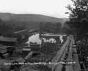
| Date: | 08 29 1930 |
|---|---|
| Description: | View from top of new bridge of construction grounds at the bridge site. There are cars carrying building materials on the railroad tracks by the Bridgeport... |

| Date: | 08 29 1930 |
|---|---|
| Description: | Workers pose at the entrance of the old bridge. There are railroad tracks in the foreground with signs that read, "free bridge," "men working," and "cautio... |

| Date: | |
|---|---|
| Description: | View down road of entrance of bridge. A car is driving towards the viewer. Signs at the bridge entrance read: "Parking on the Bridge is Prohibited," "Wisco... |
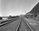
| Date: | 1925 |
|---|---|
| Description: | View down railroad tracks of the Lynxville train depot on the Chicago Burlington and Quincy Railroad line. There are bluffs on the right, and a man is walk... |

| Date: | |
|---|---|
| Description: | This 19th century manuscript map shows land claims near the confluence of the Wisconsin River with the Mississippi River in the Town of Bridgeport, Crawfor... |

| Date: | 1911 |
|---|---|
| Description: | Blue line print. Shows post offices, houses, schools, churches, roads, routes, rivers, and railroads. Includes explanation of symbols. "H.G.M. October 12,... |

| Date: | 07 04 1965 |
|---|---|
| Description: | Text on back of Pairing, "Sunrise on treetops along the north shore of the Wisconsin River, near Boscobel, but in Crawford County." Fog fills the middle gr... |

| Date: | 1838 |
|---|---|
| Description: | This map is a development plat that shows street names, numbered blocks and lots, and small farm lot owners. Included on the right of the map is a large am... |

| Date: | 05 21 1855 |
|---|---|
| Description: | This plat map shows lots, the Kickapoo River, and the Wisconsin River. |
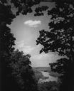
| Date: | 1950 |
|---|---|
| Description: | Elevated view of the Wisconsin River from Wyalusing State Park, framed by trees. There is a bridge over the river in the distance. |
If you didn't find the material you searched for, our Library Reference Staff can help.
Call our reference desk at 608-264-6535 or email us at: