 Filter: Categories of Wisconsin Historical Images
Filter: Subject of Wisconsin River (Wis.)
Filter: Community of Stevens Point
Filter: Categories of Wisconsin Historical Images
Filter: Subject of Wisconsin River (Wis.)
Filter: Community of Stevens Point

| Date: | 05 16 1994 |
|---|---|
| Description: | The front side of this map shows roads, highways, the Wisconsin River, Stevens Point Airport, and surrounding towns. A street index is included along the r... |

| Date: | |
|---|---|
| Description: | Colortone postcard of boats near the shore, and a building in the distance. Postcard was sent to Mr. William Kruschke of Burnett Jc., from Otto Young. Capt... |

| Date: | 1907 |
|---|---|
| Description: | Text on front reads: "Paper Mill Road, Showing Plover Paper Mill, Stevens Point, Wis." View of an unpaved road leading to a paper mill on the Wisconsin Riv... |
| Date: | 04 29 1911 |
|---|---|
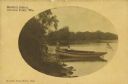
| Description: | Text on front reads: "Martin's Island, Stevens Point, Wis." Two women, one standing and one sitting behind a boat pulled up on the shore of the Wisconsin R... |

| Date: | 07 20 1931 |
|---|---|
| Description: | Text on front reads: "Clark Street Bridge, Stevens Point, Wis." View from shoreline towards a bridge built of stone, with lampposts, spanning the Wisconsin... |

| Date: | 1891 |
|---|---|
| Description: | The index page of a Sanborn Map of Stevens Point. |
If you didn't find the material you searched for, our Library Reference Staff can help.
Call our reference desk at 608-264-6535 or email us at: