 Filter: Categories of Wisconsin Historical Images
Filter: Subject of Wisconsin River (Wis.)
Filter: Creator Name of Unknown
Filter: Categories of Wisconsin Historical Images
Filter: Subject of Wisconsin River (Wis.)
Filter: Creator Name of Unknown
| Date: | |
|---|---|
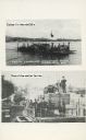
| Description: | Two images of ferries as printed on a postcard. The top image is the ferry "Colsac" on the Wisconsin River. The bottom image is simply described as an earl... |

| Date: | |
|---|---|
| Description: | The top elevated view shows the Wisconsin River with several boats. The bottom view includes the river and the Northwestern Railroad bridge from the shorel... |

| Date: | 1991 |
|---|---|
| Description: | This canoe guide depicts the Wisconsin River from just north of Prairie du Sac to near Spring Green. Landmarks and points of interest are identified and de... |

| Date: | 1900 |
|---|---|
| Description: | A map of Wisconsin, eastern Minnesota and Iowa, northern Iowa, and Michigan’s Upper Peninsula, showing railway lines, with those marked with heavy red line... |

| Date: | 1854 |
|---|---|
| Description: | This map is ink and watercolor on tracing cloth and shows lot and block numbers, streets, a park, and depots. Some lots are colored red or blue and some in... |

| Date: | 1978 |
|---|---|
| Description: | Students at Wausau West High School involved in an innovative science project that studied energy consumption and pollution of the Wisconsin River. |

| Date: | 1835 |
|---|---|
| Description: | Plat for a proposed Sinsinawa City (never built), in Grant County, Wis. When it became clear in the mid-1830s that Wisconsin Territory would be established... |

| Date: | 1912 |
|---|---|
| Description: | This outline map of Sauk County, Wisconsin, shows the towns, cities and villages, railroads, and streams in the county. |

| Date: | 1990 |
|---|---|
| Description: | This late 20th century tourist map of Sauk County, Wisconsin, shows the highways and roads, cities and towns, parks, airports, canoe landings, hospitals, s... |

| Date: | |
|---|---|
| Description: | This 19th century manuscript map shows land claims near the confluence of the Wisconsin River with the Mississippi River in the Town of Bridgeport, Crawfor... |

| Date: | 1887 |
|---|---|
| Description: | Map of the Fox and Wisconsin Rivers to accompany Reuben Gold Thwaites' Historic Waterways. |
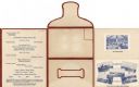
| Date: | 09 05 1926 |
|---|---|
| Description: | Dinner menu for the Hotel Witter, with menu listing, flap, front, and back of self-folding mailer, and tipped-in photographic views of the dining room and ... |

| Date: | |
|---|---|
| Description: | Photographic postcard view of a covered bridge over the Wisconsin River. Men are fishing at the base of a pylon, and other men are boating in the river. Th... |

| Date: | |
|---|---|
| Description: | Photographic postcard view of two steamboats on the Wisconsin River. Tree-covered bluffs are on the opposite shoreline. The steamboat on the left is the "G... |

| Date: | 1910 |
|---|---|
| Description: | This map of Stevens Point shows the Wisconsin River, labeled plat additions, numbered lots, and some land ownership. An inset map in the bottom left corner... |

| Date: | 1887 |
|---|---|
| Description: | This map of Tomahawk shows the Wisconsin River, numbered lots, and labeled streets. The back of the map reads: "Henry C. Payne, 424 Broadway, - - Milwaukee... |

| Date: | 1905 |
|---|---|
| Description: | Picnicking group of men and women along the shore of the Wisconsin River. |
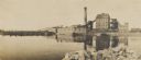
| Date: | 1905 |
|---|---|
| Description: | Semi-panoramic view of the Nekoosa Paper Company plant on the Wisconsin River. |
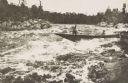
| Date: | 1900 |
|---|---|
| Description: | Lumbermen in a bateau descending rapids in an unidentified northern or north-central Wisconsin river. |

| Date: | 1880 |
|---|---|
| Description: | View of flood damage, showing wrecked buildings along the Wisconsin River waterfront. |
If you didn't find the material you searched for, our Library Reference Staff can help.
Call our reference desk at 608-264-6535 or email us at: