Filter: Categories of Wisconsin Historical Images
Filter: Subject of Wisconsin River (Wis.)
Filter: Creator Name of Unknown
Filter: Subject of architecture
Filter: Categories of Wisconsin Historical Images
Filter: Subject of Wisconsin River (Wis.)
Filter: Creator Name of Unknown
Filter: Subject of architecture

| Date: | 1879 |
|---|---|
| Description: | This map is a bird's-eye view of Wausau, the County Seat of Marathon County. The map features an index of points of interest. |
| Date: | 1928 |
|---|---|
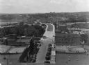
| Description: | Elevated view of the main street with the Wisconsin River in the top left corner. The street just outside the Hall Garage Company is lined with cars. |
| Date: | 1918 |
|---|---|
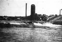
| Description: | View of the bridge over the Wisconsin River at Big Bull Falls, seen at low water. |
| Date: | 1950 |
|---|---|
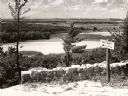
| Description: | A view from a bluff on Tower HIll overlooking the Wisconsin River. A sign on the right reads: "Shot Shaft". |

| Date: | 1965 |
|---|---|
| Description: | Aerial view that encompasses most of the town and part of the Wisconsin River. |
| Date: | 1922 |
|---|---|
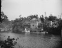
| Description: | View from shoreline across river towards the steamboat "Winnebago" docked at the Dells Boat Landing on the opposite shoreline. |

| Date: | |
|---|---|
| Description: | The steamboat "Winnebago" with passengers in front of the Dells Boat Landing. |
| Date: | 1935 |
|---|---|
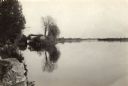
| Description: | The Wisconsin River looking downstream. The Wisconsin River end of the canal may be seen at the left. |

| Date: | |
|---|---|
| Description: | Exterior of the Consolidated Water Power and Paper Company, built in 1918. The view from across the Wisconsin River shows the company building, a dam, as w... |

| Date: | |
|---|---|
| Description: | Exterior of the Consolidated Water Power and Paper Company, built in 1918. The view from a bank of the Wisconsin River shows the company building and dam. |

| Date: | |
|---|---|
| Description: | View taken from the Paper Mill Road toward the Wisconsin River Pulp and Paper Company paper mill. On the bank in the foreground are small boats. The paper ... |

| Date: | |
|---|---|
| Description: | View of the Consolidated Paper Company Offices standing on the bank of the Wisconsin River. The Consolidated Paper Company formed in 1894. |

| Date: | |
|---|---|
| Description: | View across water toward the Consolidated Paper Company Offices and Mills, which formed in 1894. The buildings are on the bank of the Wisconsin River. |

| Date: | |
|---|---|
| Description: | Elevated view from hill toward a bridge over the Wisconsin River. |

| Date: | |
|---|---|
| Description: | Elevated view over water toward a horse and carriage and pedestrians crossing the Grand Avenue Bridge, built in 1922. Smokestacks and other buildings are o... |

| Date: | 1835 |
|---|---|
| Description: | Plat for a proposed Sinsinawa City (never built), in Grant County, Wis. When it became clear in the mid-1830s that Wisconsin Territory would be established... |
| Date: | 1905 |
|---|---|
| Description: | Semi-panoramic view of the Nekoosa Paper Company plant on the Wisconsin River. |

| Date: | 1880 |
|---|---|
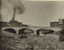
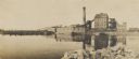
| Description: | View of flood damage, showing wrecked buildings along the Wisconsin River waterfront. |

| Date: | 1832 |
|---|---|
| Description: | This map shows lot and block numbers, as well as the location of a shot tower, houses, stores, and barns. The map is oriented with the north to the left. T... |
If you didn't find the material you searched for, our Library Reference Staff can help.
Call our reference desk at 608-264-6535 or email us at: