 Filter: Categories of Wisconsin Historical Images
Filter: Subject of Wisconsin River (Wis.)
Filter: Creator Name of Unknown
Filter: County of Crawford
Filter: Categories of Wisconsin Historical Images
Filter: Subject of Wisconsin River (Wis.)
Filter: Creator Name of Unknown
Filter: County of Crawford
| Date: | 1900 |
|---|---|
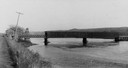
| Description: | View from road of a partially covered bridge. Industrial buildings are near the entrance to the bridge on the left. |

| Date: | 10 1905 |
|---|---|
| Description: | Elevated view from Reservoir Bluff to the east of the town. The bluffs of Iowa can be seen in the distance. |

| Date: | 1829 |
|---|---|
| Description: | Photoprint of Crawford County lead district map. |
| Date: | |
|---|---|
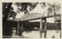
| Description: | Photographic postcard view from shoreline towards the bridge over the Wisconsin River. Caption reads: "Bridge Over Wisconsin River, Bridgeport, Wis." |

| Date: | |
|---|---|
| Description: | This 19th century manuscript map shows land claims near the confluence of the Wisconsin River with the Mississippi River in the Town of Bridgeport, Crawfor... |

| Date: | 1838 |
|---|---|
| Description: | This map is a development plat that shows street names, numbered blocks and lots, and small farm lot owners. Included on the right of the map is a large am... |

| Date: | 05 21 1855 |
|---|---|
| Description: | This plat map shows lots, the Kickapoo River, and the Wisconsin River. |
If you didn't find the material you searched for, our Library Reference Staff can help.
Call our reference desk at 608-264-6535 or email us at:
