 Filter: Categories of Wisconsin Historical Images
Filter: Subject of Wisconsin River (Wis.)
Filter: Type of Map or Atlas
Filter: Categories of Wisconsin Historical Images
Filter: Subject of Wisconsin River (Wis.)
Filter: Type of Map or Atlas

| Date: | 1856 |
|---|---|
| Description: | This plat shows block and lot numbers and land reserved for a railroad and passenger depot. The map includes certifications and registration. Kilbourn City... |

| Date: | 1982 |
|---|---|
| Description: | Color map. "Topography by photogrammetric methods from aerial photographs taken 1963. Revised from aerial photographs taken 1978. Field checked 1979. Map e... |

| Date: | 1876 |
|---|---|
| Description: | A hand-colored map on six sheets, this map of Juneau County indicates the locations of townships and sections, landowners and acreages, roads, wagon roads,... |

| Date: | 01 01 1856 |
|---|---|
| Description: | This map is mounted on cloth and shows lots, as well as location of the public square and college. Streets are labeled as is the Wisconsin River. |

| Date: | 06 1931 |
|---|---|
| Description: | This map is a photocopy of a map that has been hand-colored and shows streets, the Wisconsin River, Mill Pond, and points of interest that include a school... |

| Date: | 1800 |
|---|---|
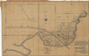
| Description: | This map is pencil on tracing paper and shows marshes, the Wisconsin River, Indian trails, and Indian boundary line. The upper left corner reads: "Let sect... |

| Date: | 1920 |
|---|---|
| Description: | This street map was likely given out by the Rebholz Company: Clothiers and Furnishers. The map shows labeled streets, train tracks, Silver Lake, Mud Lake, ... |

| Date: | 1915 |
|---|---|
| Description: | This map is mounted on cloth and shows lots and landownership, selected buildings, roads, railroads, parks, cemeteries, city wards, and includes advertisem... |

| Date: | 1987 |
|---|---|
| Description: | This pictorial map shows roads, bridges, local businesses with phone numbers, and public buildings. Relief is shown pictorially. Also included is a calen... |

| Date: | 1838 |
|---|---|
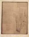
| Description: | This map is a development plat that shows street names, numbered blocks and lots, and small farm lot owners. Included on the right of the map is a large am... |

| Date: | 05 21 1855 |
|---|---|
| Description: | This plat map shows lots, the Kickapoo River, and the Wisconsin River. |

| Date: | 1986 |
|---|---|
| Description: | Pictorial map showing businesses with phone numbers, roads, railroads, and parks. Includes text titled: "History of Portage County." |

| Date: | 11 1836 |
|---|---|
| Description: | This map is pen-and-ink on paper and is a plat of a paper city on the Wisconsin River, in what is now the Town of Dekorra. The map shows lot and block numb... |

| Date: | |
|---|---|
| Description: | This plat map shows lots and block numbers of a paper city located on the Wisconsin River and Hasting’s Creek, in what is now the Town of West Point, Colum... |

| Date: | 1836 |
|---|---|
| Description: | This map shows lot and block numbers, streets, a proposed canal basin, Fort Winnebago, and the Wisconsin and Fox Rivers. Relief is shown by hachures and no... |

| Date: | 1855 |
|---|---|
| Description: | This map shows landownership, lot and block numbers, streets, a canal, bridges, Fort Winnebago, the Wisconsin River, and the Fox River. Relief is shown by ... |
| Date: | 1932 |
|---|---|
| Description: | This blue line print plat map shows local streets, numbered blocks and lots, village limits, and land ownership by name. Also included are manuscript annot... |
| Date: | 1900 |
|---|---|
| Description: | This map shows areas of Merrill, Corning, Scott, Rock Falls, Russel, Pelisan, Pine River, Ackley, and the Wisconsin River. The left margin of the map inclu... |

| Date: | 02 1937 |
|---|---|
| Description: | This topographical map of the forest preserve shows highways, roads, trails, telephone lines, Native American reservations, Ranger sub-stations, state nurs... |

| Date: | 1853 |
|---|---|
| Description: | This map shows camps, forts, logging camps, lakes, roads, railroads, the Wisconsin River, and Lac Du Flambeau Indian Reservation. Some points of interest a... |
If you didn't find the material you searched for, our Library Reference Staff can help.
Call our reference desk at 608-264-6535 or email us at: