 Filter: Categories of Wisconsin Historical Images
Filter: Subject of Wisconsin
Filter: Year of 1900-1999
Filter: Year of 1940-1949
Filter: Categories of Wisconsin Historical Images
Filter: Subject of Wisconsin
Filter: Year of 1900-1999
Filter: Year of 1940-1949
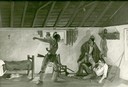
| Date: | 1940 |
|---|---|
| Description: | Photograph of a painting by Cal Peters depicting the Winnebago attack on the Gagnier homestead in 1827 and the killing of Registre Gagnier. The homestead w... |
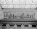
| Date: | 02 04 1945 |
|---|---|
| Description: | The mural depicts a trading station on the borders of a lake, the Whites and Indians are bargaining for furs, and the canoe is the means of transportation.... |
| Date: | 1942 |
|---|---|
| Description: | A Menominee ceremonial dance. The dancers are wearing Native American ceremonial dress. Although Roman Catholic missions had banned many Native American ce... |

| Date: | 1941 |
|---|---|
| Description: | Joe Stoddard of the Chippewa tribe harvesting wild rice on the Bad River Indian Reservation. |

| Date: | 03 05 1945 |
|---|---|
| Description: | Native American artist working at an easel, taken for WHA, the Wisconsin State radio station. |

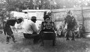
| Date: | 07 27 1948 |
|---|---|
| Description: | Three campers under the Camp Wakanda emblem, the Giant Eagle, at the camp's council ring are, left to right: Robert Hesse, son of Mr. and Mrs. Robert Hesse... |
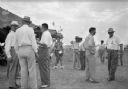
| Date: | 1940 |
|---|---|
| Description: | Men in summer clothes stand in small groups outside of a large canvas tent. The men on the right wear badges with ribbons. In the background, a man in Nati... |
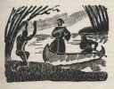
| Date: | 1941 |
|---|---|
| Description: | Woodcut illustration of a missionary priest wearing a robe standing in the fore of a canoe as it comes ashore paddled by a person in the aft. An Indian on ... |
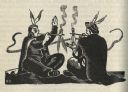
| Date: | 1941 |
|---|---|
| Description: | Woodcut illustration of two seated figures smoking pipes. |
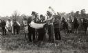
| Date: | 1949 |
|---|---|
| Description: | Historical re-enactment outdoors, in inappropriate attire, probably meant to represent a treaty signing, at the Grignon House. |

| Date: | 1941 |
|---|---|
| Description: | Hand-drawn, watercolor and ink, map of Lake Mendota. Locations and many small figures appear around the shore with explanations referring to Indian legends... |

| Date: | 1943 |
|---|---|
| Description: | A map that shows the lands for sale by the Tomahawk Land Company of Tomahawk, Wisconsin, in the counties of Langlade, Lincoln, Oneida, and Price. The map s... |

| Date: | 1941 |
|---|---|
| Description: | A pictorial map of Lake Mendota that shows Indian sites and legends associated with the Lake and its surrounding area. Some of those mentioned on the map i... |

| Date: | 1941 |
|---|---|
| Description: | This pictorial map shows sites related to Indian legends, mounds, and trails in the Chain O' Lakes region in southwestern Waupaca County, Wisconsin. |

| Date: | 1941 |
|---|---|
| Description: | This map is ink and watercolor on cardboard and shows Native American legends and villages pictorially. Trails are also shown. |

| Date: | 1945 |
|---|---|
| Description: | This maps shows roads, railroads, parks, recreational areas, Lake Wingra, Lake Monona, and part of Lake Mendota. The map includes pictorial images that dep... |

| Date: | 1949 |
|---|---|
| Description: | This pictorial map shows the United States west of the Mississippi, including Indian Tribes, historic trails, forts, trading posts, mountain ranges, lakes ... |

| Date: | 1947 |
|---|---|
| Description: | This map shows the territories of Chippewa, Sioux, Winnebago, and Monomone tribes. It also shows navigation notes for rivers and lakes, Indian villages, hi... |

| Date: | 12 1941 |
|---|---|
| Description: | A Wisconsin Indians diorama in an exhibit at the Wisconsin Historical Society. Two figures are standing behind a tree, another figure is sitting at the ent... |
If you didn't find the material you searched for, our Library Reference Staff can help.
Call our reference desk at 608-264-6535 or email us at: