 Filter: Categories of Wisconsin Historical Images
Filter: Subject of Wisconsin
Filter: Year of 1900-1999
Filter: Categories of Wisconsin Historical Images
Filter: Subject of Wisconsin
Filter: Year of 1900-1999

| Date: | 1916 |
|---|---|
| Description: | In 1916, it was estimated that 15,000 Indian mounds had formerly existed in Wisconsin. In the early 20th century, the Wisconsin Archaeological Society surv... |

| Date: | 1979 |
|---|---|
| Description: | A map of Southern Wisconsin and northern Illinois showing the areas inhabited by the Ho-Chuck, formerly known as the Winnebago. Some of the location names ... |

| Date: | 1921 |
|---|---|
| Description: | A man sits on top of a mound near Trade Lake. |

| Date: | 1921 |
|---|---|
| Description: | Three men and four children standing on top of a mound near Round Lake. |

| Date: | 1927 |
|---|---|
| Description: | Three men and two women sit on top of a mound near Trade Lake. |

| Date: | 1922 |
|---|---|
| Description: | A map of Iron County, Wisconsin, shows sections and the towns of Upson, Hurley, Hamilton, Saxon, and Mercer, lakes and streams, villages, railroads, roads ... |

| Date: | 1935 |
|---|---|
| Description: | Two hand-colored maps of the area comprising the town of Millston (Plats of Townships 20 and 21 north, range 2 west), Jackson County, Wisconsin, showing 40... |

| Date: | 1941 |
|---|---|
| Description: | A pictorial map of Lake Mendota that shows Indian sites and legends associated with the Lake and its surrounding area. Some of those mentioned on the map i... |

| Date: | 1941 |
|---|---|
| Description: | This pictorial map shows sites related to Indian legends, mounds, and trails in the Chain O' Lakes region in southwestern Waupaca County, Wisconsin. |
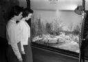
| Date: | 01 31 1959 |
|---|---|
| Description: | Staff members Mary Bolgrien (left) and Kathy Martin view a miniature exhibit of Indian life at the Wisconsin Historical Society. |

| Date: | 04 25 1961 |
|---|---|
| Description: | Chief No-Ha-Nutch'Ka,left, who is actually Jack Grey, head of public relations for Wisconsin Dells, gives Chamber of Commerce members tips on how to gain m... |

| Date: | 07 16 1960 |
|---|---|
| Description: | Several participants tell the early history of Mendota State Hospital at the centennial pageant. They are, left to right: Cecilia Shedleski, a nurse at the... |

| Date: | 1924 |
|---|---|
| Description: | This pictorial map focuses on the Madison Isthmus, Lake Mendota, Lake Monona, Lake Wingra, and shows points of historical interest, buildings, parks, and I... |

| Date: | 1941 |
|---|---|
| Description: | This map is ink and watercolor on cardboard and shows Native American legends and villages pictorially. Trails are also shown. |

| Date: | 1945 |
|---|---|
| Description: | This maps shows roads, railroads, parks, recreational areas, Lake Wingra, Lake Monona, and part of Lake Mendota. The map includes pictorial images that dep... |
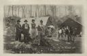
| Date: | 1920 |
|---|---|
| Description: | Informal outdoor group portrait of Native American men and boys. One man is wearing a feather on his head, a beaded sash, and beaded pants. Two buildings a... |
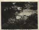
| Date: | 1920 |
|---|---|
| Description: | View of the cemetery at Skunk Hill (Tah-qua-kik). |

| Date: | 1939 |
|---|---|
| Description: | This illustrated map shows counties, highways, rivers, roads, present and proposed state parks and forests, proposed state parkways, proposed state monumen... |

| Date: | 1923 |
|---|---|
| Description: | This map shows counties, roads, Lake Superior, Lake Michigan, and portions of surrounding states. Included is an index to cities, villages and other places... |

| Date: | 1921 |
|---|---|
| Description: | This map shows counties, roads, Lake Superior, Lake Michigan, and portions of surrounding states. Included is an index to cities, villages and other places... |
If you didn't find the material you searched for, our Library Reference Staff can help.
Call our reference desk at 608-264-6535 or email us at: