 Filter: Categories of Wisconsin Historical Images
Filter: Subject of Wisconsin
Filter: Subject of wisconsin river (wis.)
Filter: Categories of Wisconsin Historical Images
Filter: Subject of Wisconsin
Filter: Subject of wisconsin river (wis.)
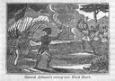
| Date: | 1845 |
|---|---|
| Description: | Engraving depicting the defeat of Black Hawk by General Henry Atkinson at the Battle of Bad Axe on August 2, 1832. The engraving depicts Federal Regulars a... |
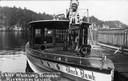
| Date: | |
|---|---|
| Description: | Chief Whirling Thunder, standing at the front of an excursion boat named "Black Hawk," which appears to be near the Wisconsin Dells. Caption reads: "Chief ... |

| Date: | 1952 |
|---|---|
| Description: | The famous Dells of the Wisconsin River. A souvenir map embellished with bits of history and points of interest. |

| Date: | 1899 |
|---|---|
| Description: | This color map, originally published in the Smithsonian Institution Bureau of American Ethnology's 18th annual report, shows the Indian land cessions in Wi... |

| Date: | 1800 |
|---|---|
| Description: | This map is pencil on tracing paper and shows marshes, the Wisconsin River, Indian trails, and Indian boundary line. The upper left corner reads: "Let sect... |

| Date: | 1838 |
|---|---|
| Description: | This map is a development plat that shows street names, numbered blocks and lots, and small farm lot owners. Included on the right of the map is a large am... |
| Date: | |
|---|---|
| Description: | A Native American Indian in native dress, including a beaded bandolier and feathered headdress, gazing out to the Wisconsin River. He is standing on a rock... |

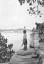
| Date: | |
|---|---|
| Description: | A young Native American Indian boy in traditional dress is posing on a rock formation above the Wisconsin River. In the background is a steamboat on the ri... |

| Date: | |
|---|---|
| Description: | Group portrait of older men, with younger men and a boy, posing on a rock formation above the Wisconsin River. They are all wearing traditional clothing, i... |
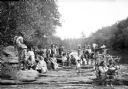
| Date: | |
|---|---|
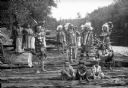
| Description: | A large group of Native Americans, men, women and children, posing on rocks along the Wisconsin River. They are wearing traditional clothing, and some of t... |
| Date: | |
|---|---|
| Description: | Group portrait of Native Americans, including Ho-Chunk, Sioux, Kiowa and southwestern Native American tribes, posing on rocks along the Wisconsin River wea... |
| Date: | |
|---|---|
| Description: | Outdoor portrait of a Native American man with his arms crossed over his chest standing on rocks near the Wisconsin River. He is wearing a headdress, a pat... |

| Date: | 1929 |
|---|---|
| Description: | This map with north oriented to the upper left shows military forts, Indian villages, settler's houses with surnames, trading houses, lodges and encampment... |

| Date: | 1755 |
|---|---|
| Description: | Map of the Great Lakes region during the French and Indian War. It shows in great detail the territories, borders and boundary lines, Native American tribe... |
If you didn't find the material you searched for, our Library Reference Staff can help.
Call our reference desk at 608-264-6535 or email us at: