 Filter: Categories of Wisconsin Historical Images
Filter: Subject of Wisconsin
Filter: Subject of water
Filter: Subject of intellectual life
Filter: Categories of Wisconsin Historical Images
Filter: Subject of Wisconsin
Filter: Subject of water
Filter: Subject of intellectual life

| Date: | 1955 |
|---|---|
| Description: | Artist's conception of ancient village of Aztalan, fortified with high walls surrounding it. |
| Date: | |
|---|---|
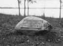
| Description: | View of a rock with a plaque that reads: "Group of Prehistoric Indian Burial Mounds and Winnebago Village Site. Marked by the Delavan Woman's Club - May 19... |

| Date: | 1851 |
|---|---|
| Description: | Map of a portion of Merton including the Bark River, a mill, Fort Hill, and Indian mounds. |

| Date: | |
|---|---|
| Description: | Letterhead of the Chippewa Springs Corporation of Chippewa Falls, Wisconsin, featuring the Chippewa Natural Spring Water logo of an American Indian man in ... |

| Date: | 1916 |
|---|---|
| Description: | In 1916, it was estimated that 15,000 Indian mounds had formerly existed in Wisconsin. In the early 20th century, the Wisconsin Archaeological Society surv... |

| Date: | |
|---|---|
| Description: | Back, front, and inside front cover of the menu from The Restaurant at Baron's department store, with "A Historical Map of Madison" focusing on the isthmus... |

| Date: | 1924 |
|---|---|
| Description: | This pictorial map focuses on the Madison Isthmus, Lake Mendota, Lake Monona, Lake Wingra, and shows points of historical interest, buildings, parks, and I... |

| Date: | 1941 |
|---|---|
| Description: | This map is ink and watercolor on cardboard and shows Native American legends and villages pictorially. Trails are also shown. |

| Date: | 1937 |
|---|---|
| Description: | Pictorial map showing historical events and locations within the state of Wisconsin, as well as waterways and counties. Original caption on the bottom marg... |

| Date: | 1982 |
|---|---|
| Description: | This map shows the location of major settlement regions for various ethnic groups. Includes a legend in lower left hand corner. Sparse settlement is repres... |

| Date: | 1899 |
|---|---|
| Description: | This map shows color coded and numbered regions of Indian land cessions. Lake Superior and Lake Michigan are labeled and other lakes and rivers are shown. ... |

| Date: | 1900 |
|---|---|
| Description: | This manuscript map shows outline of Fort Winnebago reserve land, Fort Winnebago, claim of A. Grignon, and Indian boundaries. The Fox River and Swan Lake a... |

| Date: | 1758 |
|---|---|
| Description: | This detailed map of north eastern America shows the boundaries, cities, mountains, rivers, lakes, Native American land and towns, and roads from east of t... |
If you didn't find the material you searched for, our Library Reference Staff can help.
Call our reference desk at 608-264-6535 or email us at: